Tronchón geodata
Tronchón (Aragon) is a seat of a third-order administrative division; located in Spain in Europe/Madrid (GMT+2) time zone. With population of 108 people, there are 5829 cities with bigger population in this country. Compared to other cities in Spain, 59.4% of cities are located further ↑North; 83.2% of cities are located further ←West and 93.7% of cities have lower elevation than Tronchón. Note1


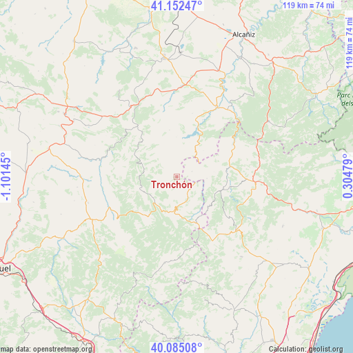
Tronchón GPS coordinates[2]
40° 37' 15.276" North, 0° 23' 53.988" West
| Map corner | latitude | longitude |
|---|---|---|
| Upper-left | 41.15247°, | -1.10145° |
| Center: | 40.62091°, | -0.39833° |
| Lower-right: | 40.08508°, | 0.30479° |
| Map W x H: | 118.7×118.7 km | = 73.8×73.8mi |
| max Lat: | 43.74134° ⇑59.4% North |
| Tronchón: | 40.62091° |
| min Lat: | ⇓40.6% South 27.64134° |
| min Long | Tronchón | max Long |
| -18.00367° | -0.39833° | 4.2899° |
| W 83.2%⇐ | ⇒16.8% E |
Elevation
Elevation of Tronchón is 1109 m = 3638 ft, and this is 511 m = 1677 ft above average elevation for this country.
| Max E: |
1682 m = 5518 ft | 6.3% |
| Tronchón | 1109 m 3638 ft | |
| Avg. | 598 m = 1962 ft | |
Min E: |
0 m = 0 ft | 93.7% |
See also: Spain elevation on elevation.city.
Geographical zone
Tronchón is located in North temperate zone (between Tropic of Cancer and the Arctic Circle). Distance of this Northern Tropic circle is 1910.7 km =1187.3 mi to South.| Distance of | km | miles | from Tronchón |
|---|---|---|---|
| North Pole | 5490.4 | 3411.6 | to North |
| Arctic Circle | 2884.6 | 1792.4 | to North |
| Tropic Cancer | 1910.7 | 1187.3 | to South |
| Equator | 4516.6 | 2806.5 | to South |


Nearby cities:
15 places around Tronchón: (largest is in red/bold)
• Bordón
9.7 km =6 mi,  41°
41°
• Cantavieja
10.5 km =6.5 mi,  183°
183°
• Castellote
21 km =13 mi,  18°
18°
• Cañada de Benatanduz
12.6 km =7.8 mi,  248°
248°
• Cinctorres
15.9 km =9.9 mi,  105°
105°
• Forcall
17 km =10.6 mi,  80°
80°
• Fortanete
16.6 km =10.3 mi,  219°
219°
• La Iglesuela del Cid
16.7 km =10.4 mi,  156°
156°
• Mirambel
6 km =3.7 mi,  128°
128°
• Olocau del Rey
5.2 km =3.2 mi,  69°
69°
• Pitarque
16.7 km =10.4 mi,  280°
280°
• Portell de Morella
15.1 km =9.4 mi, 130°
• Todolella
13.1 km =8.1 mi, 77°
• Villarluengo
11.6 km =7.2 mi,  285°
285°
• Villores
17.8 km =11.1 mi, 70°
Sources, notices
• [Note1] Compared only with cities in Spain existing in our database
• [Src1] Map data: © OpenStreetMap contributors (CC-BY-SA)
• [Src2] Other city data from geonames.org with taken over terms of usage.
• [Src3] Geographical zone / Annual Mean Temperature by Robert A. Rohde @ Wikipedia
