Gargallo geodata
Gargallo (Aragon) is a seat of a third-order administrative division; located in Spain in Europe/Madrid (GMT+2) time zone. With population of 107 people, there are 5841 cities with bigger population in this country. Compared to other cities in Spain, 55.3% of cities are located further ↑North; 80.7% of cities are located further ←West and 84.5% of cities have lower elevation than Gargallo. Note1


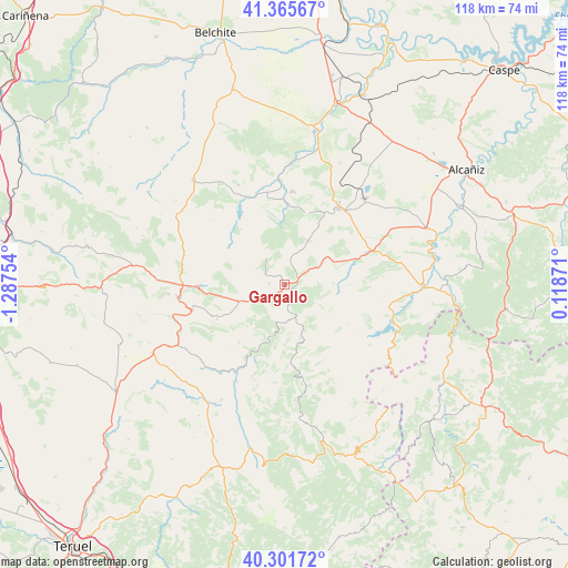
Gargallo GPS coordinates[2]
40° 50' 8.988" North, 0° 35' 3.912" West
| Map corner | latitude | longitude |
|---|---|---|
| Upper-left | 41.36567°, | -1.28754° |
| Center: | 40.83583°, | -0.58442° |
| Lower-right: | 40.30172°, | 0.11871° |
| Map W x H: | 118.3×118.3 km | = 73.5×73.5mi |
| max Lat: | 43.74134° ⇑55.3% North |
| Gargallo: | 40.83583° |
| min Lat: | ⇓44.7% South 27.64134° |
| min Long | Gargallo | max Long |
| -18.00367° | -0.58442° | 4.2899° |
| W 80.7%⇐ | ⇒19.3% E |
Elevation
Elevation of Gargallo is 945 m = 3100 ft, and this is 347 m = 1138 ft above average elevation for this country.
| Max E: |
1682 m = 5518 ft | 15.5% |
| Gargallo | 945 m 3100 ft | |
| Avg. | 598 m = 1962 ft | |
Min E: |
0 m = 0 ft | 84.5% |
See also: Spain elevation on elevation.city.
Geographical zone
Gargallo is located in North temperate zone (between Tropic of Cancer and the Arctic Circle). Distance of this Northern Tropic circle is 1934.6 km =1202.1 mi to South.| Distance of | km | miles | from Gargallo |
|---|---|---|---|
| North Pole | 5466.5 | 3396.7 | to North |
| Arctic Circle | 2860.7 | 1777.6 | to North |
| Tropic Cancer | 1934.6 | 1202.1 | to South |
| Equator | 4540.5 | 2821.3 | to South |


Nearby cities:
15 places around Gargallo: (largest is in red/bold)
• Alcaine
16.6 km =10.3 mi,  322°
322°
• Alcorisa
18.2 km =11.3 mi,  69°
69°
• Alloza
15.6 km =9.7 mi,  17°
17°
• Andorra
19.4 km =12.1 mi,  36°
36°
• Berge
13.5 km =8.4 mi,  79°
79°
• Castel de Cabra
10.1 km =6.3 mi,  248°
248°
• Cañizar del Olivar
5.6 km =3.5 mi, 247°
• Crivillén
5.3 km =3.3 mi,  7°
7°
• Ejulve
7.1 km =4.4 mi,  158°
158°
• Estercuel
4.5 km =2.8 mi,  297°
297°
• Molinos
11.4 km =7.1 mi,  98°
98°
• Montalbán
18.3 km =11.4 mi,  268°
268°
• Obón
13.9 km =8.6 mi, 303°
• Palomar de Arroyos
15.3 km =9.5 mi, 245°
• Torre de las Arcas
11.2 km =7 mi, 273°
Sources, notices
• [Note1] Compared only with cities in Spain existing in our database
• [Src1] Map data: © OpenStreetMap contributors (CC-BY-SA)
• [Src2] Other city data from geonames.org with taken over terms of usage.
• [Src3] Geographical zone / Annual Mean Temperature by Robert A. Rohde @ Wikipedia
