Villarejo de Salvanés geodata
Villarejo de Salvanés (Madrid) is a populated place; located in Spain in Europe/Madrid (GMT+2) time zone. With population of 6,420 people, there are 1091 cities with bigger population in this country. Compared to other cities in Spain, 67.7% of cities are located further ↑North; 50.7% of cities are located further ←West and 61.6% of cities have lower elevation than Villarejo de Salvanés. Note1
Current local time in Villarejo de Salvanés:
10:42 PM, ThursdayDifference from your time zone: hours


Villarejo de Salvanés GPS coordinates[2]
40° 9' 59.868" North, 3° 16' 21.972" West
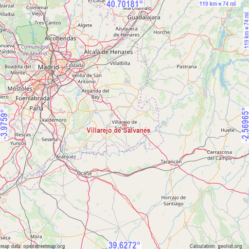
| Map corner | latitude | longitude |
|---|---|---|
| Upper-left | 40.70181°, | -3.9759° |
| Center: | 40.16663°, | -3.27277° |
| Lower-right: | 39.6272°, | -2.56965° |
| Map W x H: | 119.5×119.5 km | = 74.3×74.3mi |
| max Lat: | 43.74134° ⇑67.7% North |
| Villarejo de Salvanés: | 40.16663° |
| min Lat: | ⇓32.3% South 27.64134° |
| min Long | Villarejo de Sa | max Long |
| -18.00367° | -3.27277° | 4.2899° |
| W 50.7%⇐ | ⇒49.3% E |
Elevation
Elevation of Villarejo de Salvanés is 755 m = 2477 ft, and this is 157 m = 515 ft above average elevation for this country.
| Max E: |
1682 m = 5518 ft | 38.4% |
| Villarejo de Salvanés | 755 m 2477 ft | |
| Avg. | 598 m = 1962 ft | |
Min E: |
0 m = 0 ft | 61.6% |
See also: Spain elevation on elevation.city.
Geographical zone
Villarejo de Salvanés is located in North temperate zone (between Tropic of Cancer and the Arctic Circle). Distance of this Northern Tropic circle is 1860.2 km =1155.9 mi to South.| Distance of | km | miles | from Villarejo de Salvanés |
|---|---|---|---|
| North Pole | 5541 | 3443 | to North |
| Arctic Circle | 2935.1 | 1823.8 | to North |
| Tropic Cancer | 1860.2 | 1155.9 | to South |
| Equator | 4466.1 | 2775.1 | to South |


Nearby cities:
15 places around Villarejo de Salvanés: (largest is in red/bold)
• Belmonte de Tajo
6.6 km =4.1 mi,  233°
233°
• Brea de Tajo
16.4 km =10.2 mi,  63°
63°
• Carabaña
10.2 km =6.3 mi,  17°
17°
• Chinchón
13.1 km =8.1 mi,  257°
257°
• Colmenar de Oreja
11.7 km =7.3 mi,  235°
235°
• Estremera
14.8 km =9.2 mi,  82°
82°
• Fuentidueña de Tajo
11.3 km =7 mi,  119°
119°
• Morata de Tajuña
15.1 km =9.4 mi,  296°
296°
• Orusco
14.1 km =8.8 mi, 23°
• Perales de Tajuña
9.7 km =6 mi,  317°
317°
• Tielmes
9.6 km =6 mi,  338°
338°
• Valdaracete
8.3 km =5.2 mi, 56°
• Valdilecha
14.5 km =9 mi,  350°
350°
• Villamanrique de Tajo
11.6 km =7.2 mi,  164°
164°
• Villar del Olmo
19 km =11.8 mi,  9°
9°
Sources, notices
• [Note1] Compared only with cities in Spain existing in our database
• [Src1] Map data: © OpenStreetMap contributors (CC-BY-SA)
• [Src2] Other city data from geonames.org with taken over terms of usage.
• [Src3] Geographical zone / Annual Mean Temperature by Robert A. Rohde @ Wikipedia
