Estremera geodata
Estremera (Madrid) is a seat of a third-order administrative division; located in Spain in Europe/Madrid (GMT+2) time zone. With population of 1,180 people, there are 2737 cities with bigger population in this country. Compared to other cities in Spain, 67.5% of cities are located further ↑North; 52.7% of cities are located further ←West and 52.7% of cities have higher elevation than Estremera. Note1


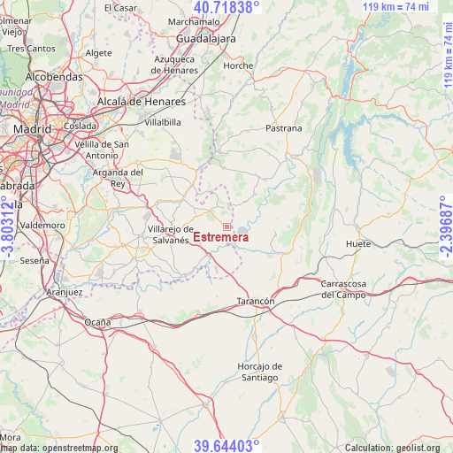
Estremera GPS coordinates[2]
40° 10' 59.988" North, 3° 6' 0" West
| Map corner | latitude | longitude |
|---|---|---|
| Upper-left | 40.71838°, | -3.80312° |
| Center: | 40.18333°, | -3.1° |
| Lower-right: | 39.64403°, | -2.39687° |
| Map W x H: | 119.5×119.5 km | = 74.3×74.3mi |
| max Lat: | 43.74134° ⇑67.5% North |
| Estremera: | 40.18333° |
| min Lat: | ⇓32.5% South 27.64134° |
| min Long | Estremera | max Long |
| -18.00367° | -3.1° | 4.2899° |
| W 52.7%⇐ | ⇒47.3% E |
Elevation
Elevation of Estremera is 626 m = 2054 ft, and this is 28 m = 92 ft above average elevation for this country.
| Max E: |
1682 m = 5518 ft | 52.7% |
| Estremera | 626 m 2054 ft | |
| Avg. | 598 m = 1962 ft | |
Min E: |
0 m = 0 ft | 47.3% |
See also: Spain elevation on elevation.city.
Geographical zone
Estremera is located in North temperate zone (between Tropic of Cancer and the Arctic Circle). Distance of this Northern Tropic circle is 1862 km =1157 mi to South.| Distance of | km | miles | from Estremera |
|---|---|---|---|
| North Pole | 5539.1 | 3441.8 | to North |
| Arctic Circle | 2933.2 | 1822.6 | to North |
| Tropic Cancer | 1862 | 1157 | to South |
| Equator | 4468 | 2776.3 | to South |


Nearby cities:
15 places around Estremera: (largest is in red/bold)
• Albares
15.8 km =9.8 mi,  29°
29°
• Almoguera
16.1 km =10 mi,  38°
38°
• Barajas de Melo
16.9 km =10.5 mi,  113°
113°
• Belinchón
15.7 km =9.8 mi,  165°
165°
• Brea de Tajo
5.6 km =3.5 mi,  0°
0°
• Carabaña
14 km =8.7 mi,  304°
304°
• Driebes
8.5 km =5.3 mi, 35°
• Fuentidueña de Tajo
8.9 km =5.5 mi,  212°
212°
• Illana
16.2 km =10.1 mi,  89°
89°
• Leganiel
12.9 km =8 mi,  98°
98°
• Mazuecos
11.6 km =7.2 mi, 42°
• Mondéjar
15.3 km =9.5 mi,  357°
357°
• Orusco
14.2 km =8.8 mi,  321°
321°
• Valdaracete
8.2 km =5.1 mi,  289°
289°
• Villarejo de Salvanés
14.8 km =9.2 mi,  262°
262°
Sources, notices
• [Note1] Compared only with cities in Spain existing in our database
• [Src1] Map data: © OpenStreetMap contributors (CC-BY-SA)
• [Src2] Other city data from geonames.org with taken over terms of usage.
• [Src3] Geographical zone / Annual Mean Temperature by Robert A. Rohde @ Wikipedia
