Valdilecha geodata
Valdilecha (Madrid) is a seat of a third-order administrative division; located in Spain in Europe/Madrid (GMT+2) time zone. With population of 2,347 people, there are 1974 cities with bigger population in this country. Compared to other cities in Spain, 65.9% of cities are located further ↑North; 50.4% of cities are located further ←West and 54.6% of cities have lower elevation than Valdilecha. Note1


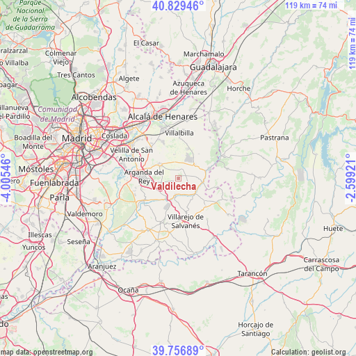
Valdilecha GPS coordinates[2]
40° 17' 43.08" North, 3° 18' 8.388" West
| Map corner | latitude | longitude |
|---|---|---|
| Upper-left | 40.82946°, | -4.00546° |
| Center: | 40.2953°, | -3.30233° |
| Lower-right: | 39.75689°, | -2.59921° |
| Map W x H: | 119.3×119.3 km | = 74.1×74.1mi |
| max Lat: | 43.74134° ⇑65.9% North |
| Valdilecha: | 40.2953° |
| min Lat: | ⇓34.1% South 27.64134° |
| min Long | Valdilecha | max Long |
| -18.00367° | -3.30233° | 4.2899° |
| W 50.4%⇐ | ⇒49.6% E |
Elevation
Elevation of Valdilecha is 705 m = 2313 ft, and this is 107 m = 351 ft above average elevation for this country.
| Max E: |
1682 m = 5518 ft | 45.4% |
| Valdilecha | 705 m 2313 ft | |
| Avg. | 598 m = 1962 ft | |
Min E: |
0 m = 0 ft | 54.6% |
See also: Spain elevation on elevation.city.
Geographical zone
Valdilecha is located in North temperate zone (between Tropic of Cancer and the Arctic Circle). Distance of this Northern Tropic circle is 1874.5 km =1164.8 mi to South.| Distance of | km | miles | from Valdilecha |
|---|---|---|---|
| North Pole | 5526.6 | 3434.1 | to North |
| Arctic Circle | 2920.8 | 1814.9 | to North |
| Tropic Cancer | 1874.5 | 1164.8 | to South |
| Equator | 4480.4 | 2784 | to South |


Nearby cities:
15 places around Valdilecha: (largest is in red/bold)
• Ambite
11.1 km =6.9 mi,  68°
68°
• Arganda
11.5 km =7.1 mi,  273°
273°
• Campo Real
8.1 km =5 mi,  301°
301°
• Carabaña
7.3 km =4.5 mi,  128°
128°
• Loeches
13.7 km =8.5 mi,  315°
315°
• Morata de Tajuña
13.4 km =8.3 mi,  235°
235°
• Nuevo Baztán
9.5 km =5.9 mi,  32°
32°
• Orusco
8.3 km =5.2 mi,  99°
99°
• Perales de Tajuña
8.2 km =5.1 mi,  209°
209°
• Pozuelo del Rey
7.8 km =4.8 mi,  350°
350°
• Tielmes
5.5 km =3.4 mi,  190°
190°
• Torres de la Alameda
12.8 km =8 mi,  338°
338°
• Valdaracete
13.6 km =8.5 mi,  135°
135°
• Valverde de Alcalá
13.5 km =8.4 mi,  2°
2°
• Villar del Olmo
7.3 km =4.5 mi,  52°
52°
Sources, notices
• [Note1] Compared only with cities in Spain existing in our database
• [Src1] Map data: © OpenStreetMap contributors (CC-BY-SA)
• [Src2] Other city data from geonames.org with taken over terms of usage.
• [Src3] Geographical zone / Annual Mean Temperature by Robert A. Rohde @ Wikipedia
