Peñausende geodata
Peñausende (Castille and León) is a seat of a third-order administrative division; located in Spain in Europe/Madrid (GMT+2) time zone. With population of 490 people, there are 3916 cities with bigger population in this country. Compared to other cities in Spain, 55.1% of cities are located further ↓South; 84.2% of cities are located further →East and 76.9% of cities have lower elevation than Peñausende. Note1
Administrative division(s):
- Level 1: Castille and León
- Level 2: Provincia de Zamora
- Level 3: Peñausende


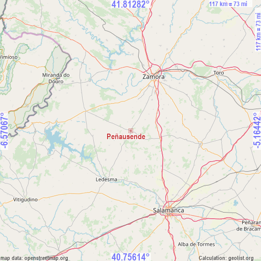
Peñausende GPS coordinates[2]
41° 17' 11.832" North, 5° 52' 3.18" West
| Map corner | latitude | longitude |
|---|---|---|
| Upper-left | 41.81282°, | -6.57067° |
| Center: | 41.28662°, | -5.86755° |
| Lower-right: | 40.75614°, | -5.16442° |
| Map W x H: | 117.5×117.5 km | = 73×73mi |
| max Lat: | 43.74134° ⇑44.9% North |
| Peñausende: | 41.28662° |
| min Lat: | ⇓55.1% South 27.64134° |
| min Long | Peñausende | max Long |
| -18.00367° | -5.86755° | 4.2899° |
| W 15.8%⇐ | ⇒84.2% E |
Elevation
Elevation of Peñausende is 870 m = 2854 ft, and this is 272 m = 892 ft above average elevation for this country.
| Max E: |
1682 m = 5518 ft | 23.1% |
| Peñausende | 870 m 2854 ft | |
| Avg. | 598 m = 1962 ft | |
Min E: |
0 m = 0 ft | 76.9% |
See also: Spain elevation on elevation.city.
Geographical zone
Peñausende is located in North temperate zone (between Tropic of Cancer and the Arctic Circle). Distance of this Northern Tropic circle is 1984.7 km =1233.2 mi to South.| Distance of | km | miles | from Peñausende |
|---|---|---|---|
| North Pole | 5416.4 | 3365.6 | to North |
| Arctic Circle | 2810.5 | 1746.4 | to North |
| Tropic Cancer | 1984.7 | 1233.2 | to South |
| Equator | 4590.6 | 2852.5 | to South |


Nearby cities:
15 places around Peñausende: (largest is in red/bold)
• Añover de Tormes
17.2 km =10.7 mi,  193°
193°
• Cabañas de Sayago
8.7 km =5.4 mi,  53°
53°
• Casaseca de Campeán
14 km =8.7 mi, 46°
• Corrales
14.3 km =8.9 mi,  56°
56°
• El Perdigón
17 km =10.6 mi,  34°
34°
• Fresno de Sayago
9.4 km =5.8 mi,  292°
292°
• Mayalde
7.1 km =4.4 mi,  124°
124°
• Moraleja de Sayago
17.3 km =10.7 mi,  221°
221°
• Palacios del Arzobispo
13.5 km =8.4 mi, 187°
• Pereruela
14.5 km =9 mi,  356°
356°
• Santa Clara de Avedillo
16.9 km =10.5 mi,  69°
69°
• Santiz
9.3 km =5.8 mi,  195°
195°
• Valdelosa
14.6 km =9.1 mi,  151°
151°
• Villanueva de Campeán
11.1 km =6.9 mi, 47°
• Zamayón
15.7 km =9.8 mi,  168°
168°
Sources, notices
• [Note1] Compared only with cities in Spain existing in our database
• [Src1] Map data: © OpenStreetMap contributors (CC-BY-SA)
• [Src2] Other city data from geonames.org with taken over terms of usage.
• [Src3] Geographical zone / Annual Mean Temperature by Robert A. Rohde @ Wikipedia
