Pereruela geodata
Pereruela (Castille and León) is a seat of a third-order administrative division; located in Spain in Europe/Madrid (GMT+2) time zone. With population of 660 people, there are 3484 cities with bigger population in this country. Compared to other cities in Spain, 58.3% of cities are located further ↓South; 84.3% of cities are located further →East and 63.8% of cities have lower elevation than Pereruela. Note1
Administrative division(s):
- Level 1: Castille and León
- Level 2: Provincia de Zamora
- Level 3: Pereruela


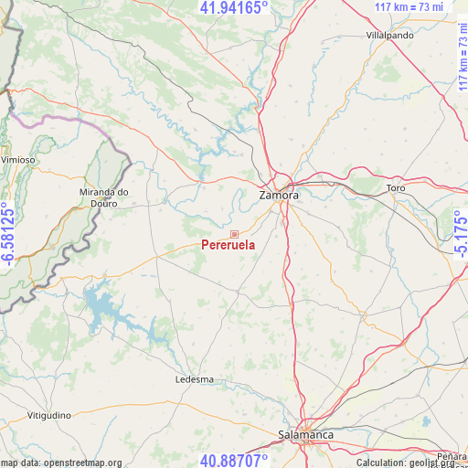
Pereruela GPS coordinates[2]
41° 24' 59.4" North, 5° 52' 41.232" West
| Map corner | latitude | longitude |
|---|---|---|
| Upper-left | 41.94165°, | -6.58125° |
| Center: | 41.4165°, | -5.87812° |
| Lower-right: | 40.88707°, | -5.175° |
| Map W x H: | 117.3×117.3 km | = 72.9×72.9mi |
| max Lat: | 43.74134° ⇑41.7% North |
| Pereruela: | 41.4165° |
| min Lat: | ⇓58.3% South 27.64134° |
| min Long | Pereruela | max Long |
| -18.00367° | -5.87812° | 4.2899° |
| W 15.7%⇐ | ⇒84.3% E |
Elevation
Elevation of Pereruela is 770 m = 2526 ft, and this is 172 m = 564 ft above average elevation for this country.
| Max E: |
1682 m = 5518 ft | 36.2% |
| Pereruela | 770 m 2526 ft | |
| Avg. | 598 m = 1962 ft | |
Min E: |
0 m = 0 ft | 63.8% |
See also: Spain elevation on elevation.city.
Geographical zone
Pereruela is located in North temperate zone (between Tropic of Cancer and the Arctic Circle). Distance of this Northern Tropic circle is 1999.2 km =1242.2 mi to South.| Distance of | km | miles | from Pereruela |
|---|---|---|---|
| North Pole | 5402 | 3356.6 | to North |
| Arctic Circle | 2796.1 | 1737.4 | to North |
| Tropic Cancer | 1999.2 | 1242.2 | to South |
| Equator | 4605.1 | 2861.5 | to South |


Nearby cities:
15 places around Pereruela: (largest is in red/bold)
• Almaraz de Duero
7.3 km =4.5 mi,  333°
333°
• Arcenillas
16.7 km =10.4 mi,  74°
74°
• Cabañas de Sayago
12.2 km =7.6 mi,  139°
139°
• Casaseca de Campeán
11.9 km =7.4 mi,  113°
113°
• Cazurra
14.5 km =9 mi,  90°
90°
• Corrales
14.3 km =8.9 mi,  116°
116°
• El Perdigón
10.5 km =6.5 mi, 92°
• Entrala
10.3 km =6.4 mi,  81°
81°
• Fresno de Sayago
13.4 km =8.3 mi,  215°
215°
• Morales del Vino
12.8 km =8 mi, 74°
• Muelas del Pan
13.9 km =8.6 mi, 326°
• Peleas de Abajo
15.9 km =9.9 mi,  99°
99°
• Peñausende
14.5 km =9 mi,  176°
176°
• Villanueva de Campeán
11.3 km =7 mi,  127°
127°
• Zamora
15 km =9.3 mi,  48°
48°
Sources, notices
• [Note1] Compared only with cities in Spain existing in our database
• [Src1] Map data: © OpenStreetMap contributors (CC-BY-SA)
• [Src2] Other city data from geonames.org with taken over terms of usage.
• [Src3] Geographical zone / Annual Mean Temperature by Robert A. Rohde @ Wikipedia
