Villanázar geodata
Villanázar (Castille and León) is a seat of a third-order administrative division; located in Spain in Europe/Madrid (GMT+2) time zone. With population of 355 people, there are 4297 cities with bigger population in this country. Compared to other cities in Spain, 73% of cities are located further ↓South; 83% of cities are located further →East and 54.7% of cities have lower elevation than Villanázar. Note1
Administrative division(s):
- Level 1: Castille and León
- Level 2: Provincia de Zamora
- Level 3: Villanázar


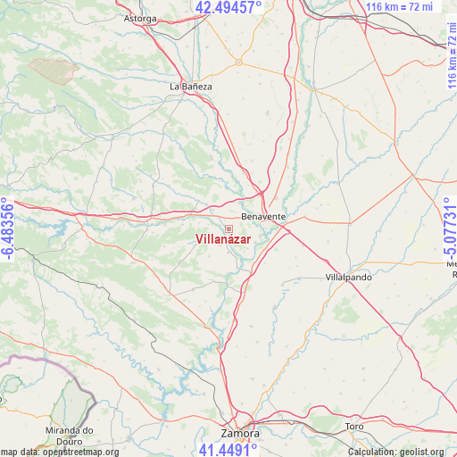
Villanázar GPS coordinates[2]
41° 58' 26.328" North, 5° 46' 49.548" West
| Map corner | latitude | longitude |
|---|---|---|
| Upper-left | 42.49457°, | -6.48356° |
| Center: | 41.97398°, | -5.78043° |
| Lower-right: | 41.4491°, | -5.07731° |
| Map W x H: | 116.2×116.2 km | = 72.2×72.2mi |
| max Lat: | 43.74134° ⇑27% North |
| Villanázar: | 41.97398° |
| min Lat: | ⇓73% South 27.64134° |
| min Long | Villanázar | max Long |
| -18.00367° | -5.78043° | 4.2899° |
| W 17%⇐ | ⇒83% E |
Elevation
Elevation of Villanázar is 707 m = 2320 ft, and this is 109 m = 358 ft above average elevation for this country.
| Max E: |
1682 m = 5518 ft | 45.3% |
| Villanázar | 707 m 2320 ft | |
| Avg. | 598 m = 1962 ft | |
Min E: |
0 m = 0 ft | 54.7% |
See also: Spain elevation on elevation.city.
Geographical zone
Villanázar is located in North temperate zone (between Tropic of Cancer and the Arctic Circle). Distance of this Northern Tropic circle is 2061.2 km =1280.8 mi to South.| Distance of | km | miles | from Villanázar |
|---|---|---|---|
| North Pole | 5340 | 3318.1 | to North |
| Arctic Circle | 2734.1 | 1698.9 | to North |
| Tropic Cancer | 2061.2 | 1280.8 | to South |
| Equator | 4667.1 | 2900 | to South |


Nearby cities:
15 places around Villanázar: (largest is in red/bold)
• Arcos de la Polvorosa
7.6 km =4.7 mi,  115°
115°
• Benavente
9 km =5.6 mi,  69°
69°
• Burganes de Valverde
5.9 km =3.7 mi,  181°
181°
• Friera de Valverde
8.5 km =5.3 mi,  216°
216°
• Manganeses de la Polvorosa
7.4 km =4.6 mi,  21°
21°
• Micereces de Tera
7.7 km =4.8 mi,  282°
282°
• Milles de la Polvorosa
6.9 km =4.3 mi,  145°
145°
• Navianos de Valverde
3.9 km =2.4 mi,  233°
233°
• Quintanilla de Urz
8.6 km =5.3 mi,  319°
319°
• Quiruelas de Vidriales
6.3 km =3.9 mi, 320°
• Santa Colomba de las Monjas
8.2 km =5.1 mi,  102°
102°
• Santa Cristina de la Polvorosa
6.2 km =3.9 mi,  62°
62°
• Villabrázaro
9.9 km =6.2 mi,  26°
26°
• Villanueva de Azoague
9.6 km =6 mi,  88°
88°
• Villaveza de Valverde
6.5 km =4 mi,  240°
240°
Sources, notices
• [Note1] Compared only with cities in Spain existing in our database
• [Src1] Map data: © OpenStreetMap contributors (CC-BY-SA)
• [Src2] Other city data from geonames.org with taken over terms of usage.
• [Src3] Geographical zone / Annual Mean Temperature by Robert A. Rohde @ Wikipedia
