Benavente geodata
Benavente (Castille and León) is a seat of a third-order administrative division; located in Spain in Europe/Madrid (GMT+2) time zone. With population of 19,119 people, there are 494 cities with bigger population in this country. Compared to other cities in Spain, 73.9% of cities are located further ↓South; 81.4% of cities are located further →East and 60.9% of cities have lower elevation than Benavente. Note1
Administrative division(s):
- Level 1: Castille and León
- Level 2: Provincia de Zamora
- Level 3: Benavente


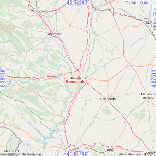
Benavente GPS coordinates[2]
42° 0' 8.964" North, 5° 40' 41.736" West
| Map corner | latitude | longitude |
|---|---|---|
| Upper-left | 42.52285°, | -6.38139° |
| Center: | 42.00249°, | -5.67826° |
| Lower-right: | 41.47784°, | -4.97513° |
| Map W x H: | 116.2×116.2 km | = 72.2×72.2mi |
| max Lat: | 43.74134° ⇑26.1% North |
| Benavente: | 42.00249° |
| min Lat: | ⇓73.9% South 27.64134° |
| min Long | Benavente | max Long |
| -18.00367° | -5.67826° | 4.2899° |
| W 18.6%⇐ | ⇒81.4% E |
Elevation
Elevation of Benavente is 750 m = 2461 ft, and this is 152 m = 499 ft above average elevation for this country.
| Max E: |
1682 m = 5518 ft | 39.1% |
| Benavente | 750 m 2461 ft | |
| Avg. | 598 m = 1962 ft | |
Min E: |
0 m = 0 ft | 60.9% |
See also: Spain elevation on elevation.city.
Geographical zone
Benavente is located in North temperate zone (between Tropic of Cancer and the Arctic Circle). Distance of this Northern Tropic circle is 2064.3 km =1282.7 mi to South.| Distance of | km | miles | from Benavente |
|---|---|---|---|
| North Pole | 5336.8 | 3316.1 | to North |
| Arctic Circle | 2730.9 | 1696.9 | to North |
| Tropic Cancer | 2064.3 | 1282.7 | to South |
| Equator | 4670.2 | 2901.9 | to South |


Nearby cities:
15 places around Benavente: (largest is in red/bold)
• Arcos de la Polvorosa
6.7 km =4.2 mi,  193°
193°
• Barcial del Barco
7.8 km =4.8 mi,  170°
170°
• Castrogonzalo
6.3 km =3.9 mi,  101°
101°
• Fresno de la Polvorosa
11.7 km =7.3 mi,  319°
319°
• Fuentes de Ropel
11 km =6.8 mi,  89°
89°
• Manganeses de la Polvorosa
6.8 km =4.2 mi,  303°
303°
• Matilla de Arzón
11.8 km =7.3 mi,  14°
14°
• Milles de la Polvorosa
9.9 km =6.2 mi,  207°
207°
• San Cristóbal de Entreviñas
6 km =3.7 mi,  36°
36°
• Santa Colomba de las Monjas
4.9 km =3 mi, 185°
• Santa Cristina de la Polvorosa
2.9 km =1.8 mi,  264°
264°
• Villabrázaro
7 km =4.3 mi, 324°
• Villanueva de Azoague
3.2 km =2 mi,  158°
158°
• Villanázar
9 km =5.6 mi,  249°
249°
• Villaveza del Agua
9.3 km =5.8 mi,  180°
180°
Sources, notices
• [Note1] Compared only with cities in Spain existing in our database
• [Src1] Map data: © OpenStreetMap contributors (CC-BY-SA)
• [Src2] Other city data from geonames.org with taken over terms of usage.
• [Src3] Geographical zone / Annual Mean Temperature by Robert A. Rohde @ Wikipedia
