Villabrázaro geodata
Villabrázaro (Castille and León) is a seat of a third-order administrative division; located in Spain in Europe/Madrid (GMT+2) time zone. With population of 376 people, there are 4224 cities with bigger population in this country. Compared to other cities in Spain, 75.2% of cities are located further ↓South; 82.1% of cities are located further →East and 57.9% of cities have lower elevation than Villabrázaro. Note1
Administrative division(s):
- Level 1: Castille and León
- Level 2: Provincia de Zamora
- Level 3: Villabrázaro


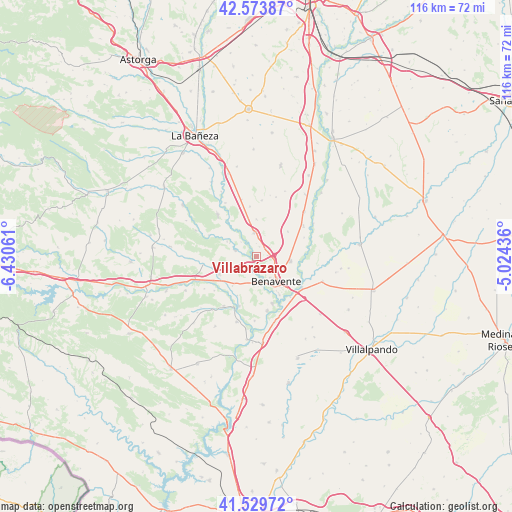
Villabrázaro GPS coordinates[2]
42° 3' 14.184" North, 5° 43' 38.928" West
| Map corner | latitude | longitude |
|---|---|---|
| Upper-left | 42.57387°, | -6.43061° |
| Center: | 42.05394°, | -5.72748° |
| Lower-right: | 41.52972°, | -5.02436° |
| Map W x H: | 116.1×116.1 km | = 72.1×72.1mi |
| max Lat: | 43.74134° ⇑24.8% North |
| Villabrázaro: | 42.05394° |
| min Lat: | ⇓75.2% South 27.64134° |
| min Long | Villabrázaro | max Long |
| -18.00367° | -5.72748° | 4.2899° |
| W 17.9%⇐ | ⇒82.1% E |
Elevation
Elevation of Villabrázaro is 729 m = 2392 ft, and this is 131 m = 430 ft above average elevation for this country.
| Max E: |
1682 m = 5518 ft | 42.1% |
| Villabrázaro | 729 m 2392 ft | |
| Avg. | 598 m = 1962 ft | |
Min E: |
0 m = 0 ft | 57.9% |
See also: Spain elevation on elevation.city.
Geographical zone
Villabrázaro is located in North temperate zone (between Tropic of Cancer and the Arctic Circle). Distance of this Northern Tropic circle is 2070 km =1286.2 mi to South.| Distance of | km | miles | from Villabrázaro |
|---|---|---|---|
| North Pole | 5331.1 | 3312.6 | to North |
| Arctic Circle | 2725.2 | 1693.4 | to North |
| Tropic Cancer | 2070 | 1286.2 | to South |
| Equator | 4676 | 2905.5 | to South |


Nearby cities:
15 places around Villabrázaro: (largest is in red/bold)
• Benavente
7 km =4.3 mi,  144°
144°
• Coomonte
9.8 km =6.1 mi,  314°
314°
• Fresno de la Polvorosa
4.8 km =3 mi, 312°
• Maire de Castroponce
8.1 km =5 mi,  324°
324°
• Manganeses de la Polvorosa
2.6 km =1.6 mi,  218°
218°
• Matilla de Arzón
9.1 km =5.7 mi,  51°
51°
• Pobladura del Valle
5.4 km =3.4 mi,  354°
354°
• Quintanilla de Urz
10.3 km =6.4 mi,  256°
256°
• Quiruelas de Vidriales
9.3 km =5.8 mi,  244°
244°
• San Adrián del Valle
8.5 km =5.3 mi,  359°
359°
• San Cristóbal de Entreviñas
7.7 km =4.8 mi,  96°
96°
• Santa Cristina de la Polvorosa
6.1 km =3.8 mi,  169°
169°
• Santa María de la Vega
7.5 km =4.7 mi,  297°
297°
• Villanueva de Azoague
10.1 km =6.3 mi,  148°
148°
• Villanázar
9.9 km =6.2 mi,  206°
206°
Sources, notices
• [Note1] Compared only with cities in Spain existing in our database
• [Src1] Map data: © OpenStreetMap contributors (CC-BY-SA)
• [Src2] Other city data from geonames.org with taken over terms of usage.
• [Src3] Geographical zone / Annual Mean Temperature by Robert A. Rohde @ Wikipedia
