Villamañán geodata
Villamañán (Castille and León) is a seat of a third-order administrative division; located in Spain in Europe/Madrid (GMT+2) time zone. With population of 1,252 people, there are 2679 cities with bigger population in this country. Compared to other cities in Spain, 82.4% of cities are located further ↓South; 79.9% of cities are located further →East and 62.6% of cities have lower elevation than Villamañán. Note1
Administrative division(s):
- Level 1: Castille and León
- Level 2: Provincia de León
- Level 3: Villamañán


Villamañán GPS coordinates[2]
42° 19' 19.128" North, 5° 34' 55.02" West
| Map corner | latitude | longitude |
|---|---|---|
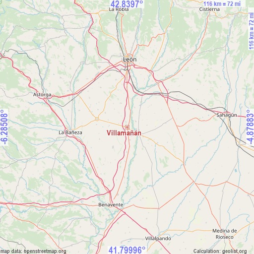
| Upper-left | 42.8397°, | -6.28508° |
| Center: | 42.32198°, | -5.58195° |
| Lower-right: | 41.79996°, | -4.87883° |
| Map W x H: | 115.6×115.6 km | = 71.8×71.8mi |
| max Lat: | 43.74134° ⇑17.6% North |
| Villamañán: | 42.32198° |
| min Lat: | ⇓82.4% South 27.64134° |
| min Long | Villamañán | max Long |
| -18.00367° | -5.58195° | 4.2899° |
| W 20.1%⇐ | ⇒79.9% E |
Elevation
Elevation of Villamañán is 762 m = 2500 ft, and this is 164 m = 538 ft above average elevation for this country.
| Max E: |
1682 m = 5518 ft | 37.4% |
| Villamañán | 762 m 2500 ft | |
| Avg. | 598 m = 1962 ft | |
Min E: |
0 m = 0 ft | 62.6% |
See also: Spain elevation on elevation.city.
Geographical zone
Villamañán is located in North temperate zone (between Tropic of Cancer and the Arctic Circle). Distance of this Northern Tropic circle is 2099.8 km =1304.8 mi to South.| Distance of | km | miles | from Villamañán |
|---|---|---|---|
| North Pole | 5301.3 | 3294.1 | to North |
| Arctic Circle | 2695.4 | 1674.8 | to North |
| Tropic Cancer | 2099.8 | 1304.8 | to South |
| Equator | 4705.8 | 2924 | to South |


Nearby cities:
15 places around Villamañán: (largest is in red/bold)
• Algadefe
11.4 km =7.1 mi,  180°
180°
• Ardón
12.8 km =8 mi,  7°
7°
• Bercianos del Páramo
12.2 km =7.6 mi,  301°
301°
• Cabreros del Río
9.5 km =5.9 mi,  20°
20°
• Cubillas de los Oteros
8.2 km =5.1 mi,  47°
47°
• Fresno de la Vega
4.6 km =2.9 mi,  55°
55°
• Laguna de Negrillos
11.3 km =7 mi,  215°
215°
• Pajares de los Oteros
9 km =5.6 mi,  84°
84°
• Pobladura de Pelayo García
8.7 km =5.4 mi,  258°
258°
• San Millán de los Caballeros
4.4 km =2.7 mi,  157°
157°
• San Pedro Bercianos
13.3 km =8.3 mi,  305°
305°
• Toral de los Guzmanes
8.9 km =5.5 mi,  172°
172°
• Valdevimbre
11.3 km =7 mi,  344°
344°
• Valencia de Don Juan
6.2 km =3.9 mi,  120°
120°
• Villademor de la Vega
5.9 km =3.7 mi, 168°
Sources, notices
• [Note1] Compared only with cities in Spain existing in our database
• [Src1] Map data: © OpenStreetMap contributors (CC-BY-SA)
• [Src2] Other city data from geonames.org with taken over terms of usage.
• [Src3] Geographical zone / Annual Mean Temperature by Robert A. Rohde @ Wikipedia
