Laguna de Negrillos geodata
Laguna de Negrillos (Castille and León) is a seat of a third-order administrative division; located in Spain in Europe/Madrid (GMT+2) time zone. With population of 1,340 people, there are 2605 cities with bigger population in this country. Compared to other cities in Spain, 80.3% of cities are located further ↓South; 81.1% of cities are located further →East and 65.7% of cities have lower elevation than Laguna de Negrillos. Note1
Administrative division(s):
- Level 1: Castille and León
- Level 2: Provincia de León
- Level 3: Laguna de Negrillos


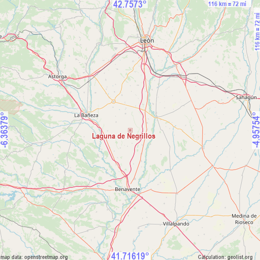
Laguna de Negrillos GPS coordinates[2]
42° 14' 20.004" North, 5° 39' 38.376" West
| Map corner | latitude | longitude |
|---|---|---|
| Upper-left | 42.7573°, | -6.36379° |
| Center: | 42.23889°, | -5.66066° |
| Lower-right: | 41.71619°, | -4.95754° |
| Map W x H: | 115.8×115.8 km | = 72×72mi |
| max Lat: | 43.74134° ⇑19.7% North |
| Laguna de Negrillos: | 42.23889° |
| min Lat: | ⇓80.3% South 27.64134° |
| min Long | Laguna de Negri | max Long |
| -18.00367° | -5.66066° | 4.2899° |
| W 18.9%⇐ | ⇒81.1% E |
Elevation
Elevation of Laguna de Negrillos is 782 m = 2566 ft, and this is 184 m = 604 ft above average elevation for this country.
| Max E: |
1682 m = 5518 ft | 34.3% |
| Laguna de Negrillos | 782 m 2566 ft | |
| Avg. | 598 m = 1962 ft | |
Min E: |
0 m = 0 ft | 65.7% |
See also: Spain elevation on elevation.city.
Geographical zone
Laguna de Negrillos is located in North temperate zone (between Tropic of Cancer and the Arctic Circle). Distance of this Northern Tropic circle is 2090.6 km =1299 mi to South.| Distance of | km | miles | from Laguna de Negrillos |
|---|---|---|---|
| North Pole | 5310.5 | 3299.8 | to North |
| Arctic Circle | 2704.6 | 1680.6 | to North |
| Tropic Cancer | 2090.6 | 1299 | to South |
| Equator | 4696.5 | 2918.3 | to South |


Nearby cities:
15 places around Laguna de Negrillos: (largest is in red/bold)
• Algadefe
6.7 km =4.2 mi,  109°
109°
• La Antigua
7.1 km =4.4 mi,  199°
199°
• Laguna Dalga
12.8 km =8 mi,  323°
323°
• Pobladura de Pelayo García
7.7 km =4.8 mi,  344°
344°
• Pozuelo del Páramo
11.6 km =7.2 mi,  229°
229°
• Roperuelos del Páramo
10 km =6.2 mi,  269°
269°
• San Adrián del Valle
13.3 km =8.3 mi,  205°
205°
• San Millán de los Caballeros
9.7 km =6 mi,  57°
57°
• Toral de los Guzmanes
7.7 km =4.8 mi,  86°
86°
• Valencia de Don Juan
13.3 km =8.3 mi, 62°
• Villademor de la Vega
8.4 km =5.2 mi,  65°
65°
• Villamandos
8.5 km =5.3 mi,  139°
139°
• Villamañán
11.3 km =7 mi,  35°
35°
• Villaquejida
11.7 km =7.3 mi,  153°
153°
• Zotes del Páramo
7.3 km =4.5 mi,  301°
301°
Sources, notices
• [Note1] Compared only with cities in Spain existing in our database
• [Src1] Map data: © OpenStreetMap contributors (CC-BY-SA)
• [Src2] Other city data from geonames.org with taken over terms of usage.
• [Src3] Geographical zone / Annual Mean Temperature by Robert A. Rohde @ Wikipedia
