Villaferrueña geodata
Villaferrueña (Castille and León) is a seat of a third-order administrative division; located in Spain in Europe/Madrid (GMT+2) time zone. With population of 154 people, there are 5393 cities with bigger population in this country. Compared to other cities in Spain, 76.4% of cities are located further ↓South; 84% of cities are located further →East and 59.9% of cities have lower elevation than Villaferrueña. Note1
Administrative division(s):
- Level 1: Castille and León
- Level 2: Provincia de Zamora
- Level 3: Villaferrueña


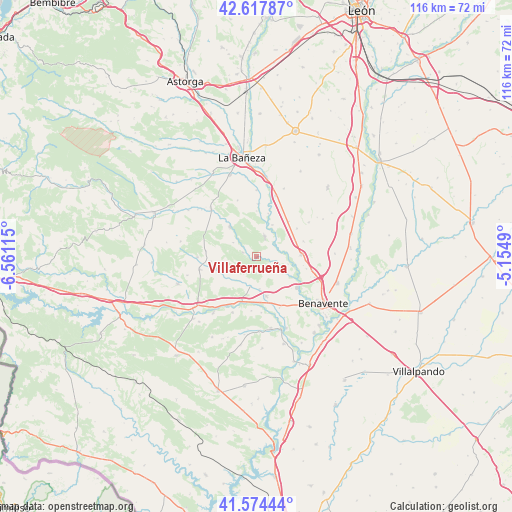
Villaferrueña GPS coordinates[2]
42° 5' 53.88" North, 5° 51' 28.872" West
| Map corner | latitude | longitude |
|---|---|---|
| Upper-left | 42.61787°, | -6.56115° |
| Center: | 42.0983°, | -5.85802° |
| Lower-right: | 41.57444°, | -5.1549° |
| Map W x H: | 116×116 km | = 72.1×72.1mi |
| max Lat: | 43.74134° ⇑23.6% North |
| Villaferrueña: | 42.0983° |
| min Lat: | ⇓76.4% South 27.64134° |
| min Long | Villaferrueña | max Long |
| -18.00367° | -5.85802° | 4.2899° |
| W 16%⇐ | ⇒84% E |
Elevation
Elevation of Villaferrueña is 744 m = 2441 ft, and this is 146 m = 479 ft above average elevation for this country.
| Max E: |
1682 m = 5518 ft | 40.1% |
| Villaferrueña | 744 m 2441 ft | |
| Avg. | 598 m = 1962 ft | |
Min E: |
0 m = 0 ft | 59.9% |
See also: Spain elevation on elevation.city.
Geographical zone
Villaferrueña is located in North temperate zone (between Tropic of Cancer and the Arctic Circle). Distance of this Northern Tropic circle is 2075 km =1289.3 mi to South.| Distance of | km | miles | from Villaferrueña |
|---|---|---|---|
| North Pole | 5326.2 | 3309.5 | to North |
| Arctic Circle | 2720.3 | 1690.3 | to North |
| Tropic Cancer | 2075 | 1289.3 | to South |
| Equator | 4680.9 | 2908.6 | to South |


Nearby cities:
15 places around Villaferrueña: (largest is in red/bold)
• Alcubilla de Nogales
6.2 km =3.9 mi,  301°
301°
• Alija de los Melones
4.9 km =3 mi,  23°
23°
• Arrabalde
3.2 km =2 mi,  289°
289°
• Brime de Urz
6.8 km =4.2 mi,  190°
190°
• Coomonte
4.2 km =2.6 mi,  62°
62°
• Fresno de la Polvorosa
7.5 km =4.7 mi,  103°
103°
• Granucillo
7.7 km =4.8 mi,  228°
228°
• Maire de Castroponce
6.3 km =3.9 mi,  75°
75°
• Pobladura del Valle
10.3 km =6.4 mi,  87°
87°
• Pozuelo del Páramo
11 km =6.8 mi,  42°
42°
• Quintanilla de Urz
7.3 km =4.5 mi,  173°
173°
• Quiruelas de Vidriales
9.3 km =5.8 mi, 165°
• San Esteban de Nogales
9.1 km =5.7 mi,  318°
318°
• Santa María de la Vega
4.3 km =2.7 mi,  109°
109°
• Villageriz
8.4 km =5.2 mi, 285°
Sources, notices
• [Note1] Compared only with cities in Spain existing in our database
• [Src1] Map data: © OpenStreetMap contributors (CC-BY-SA)
• [Src2] Other city data from geonames.org with taken over terms of usage.
• [Src3] Geographical zone / Annual Mean Temperature by Robert A. Rohde @ Wikipedia
