Coomonte geodata
Coomonte (Castille and León) is a seat of a third-order administrative division; located in Spain in Europe/Madrid (GMT+2) time zone. With population of 294 people, there are 4527 cities with bigger population in this country. Compared to other cities in Spain, 76.9% of cities are located further ↓South; 83.4% of cities are located further →East and 58.7% of cities have lower elevation than Coomonte. Note1
Administrative division(s):
- Level 1: Castille and León
- Level 2: Provincia de Zamora
- Level 3: Coomonte


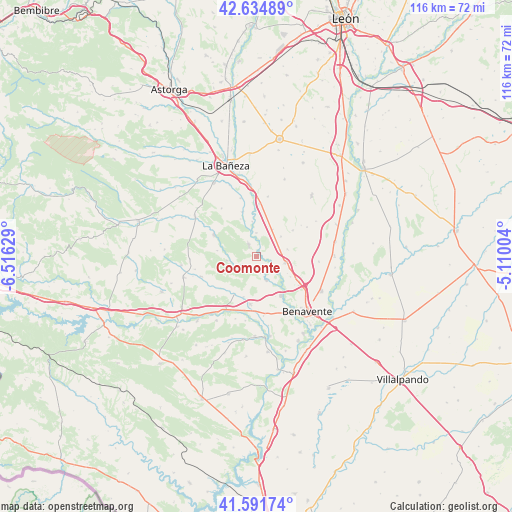
Coomonte GPS coordinates[2]
42° 6' 55.656" North, 5° 48' 47.376" West
| Map corner | latitude | longitude |
|---|---|---|
| Upper-left | 42.63489°, | -6.51629° |
| Center: | 42.11546°, | -5.81316° |
| Lower-right: | 41.59174°, | -5.11004° |
| Map W x H: | 116×116 km | = 72.1×72.1mi |
| max Lat: | 43.74134° ⇑23.1% North |
| Coomonte: | 42.11546° |
| min Lat: | ⇓76.9% South 27.64134° |
| min Long | Coomonte | max Long |
| -18.00367° | -5.81316° | 4.2899° |
| W 16.6%⇐ | ⇒83.4% E |
Elevation
Elevation of Coomonte is 735 m = 2411 ft, and this is 137 m = 449 ft above average elevation for this country.
| Max E: |
1682 m = 5518 ft | 41.3% |
| Coomonte | 735 m 2411 ft | |
| Avg. | 598 m = 1962 ft | |
Min E: |
0 m = 0 ft | 58.7% |
See also: Spain elevation on elevation.city.
Geographical zone
Coomonte is located in North temperate zone (between Tropic of Cancer and the Arctic Circle). Distance of this Northern Tropic circle is 2076.9 km =1290.5 mi to South.| Distance of | km | miles | from Coomonte |
|---|---|---|---|
| North Pole | 5324.3 | 3308.4 | to North |
| Arctic Circle | 2718.4 | 1689.1 | to North |
| Tropic Cancer | 2076.9 | 1290.5 | to South |
| Equator | 4682.8 | 2909.8 | to South |


Nearby cities:
15 places around Coomonte: (largest is in red/bold)
• Alcubilla de Nogales
9.1 km =5.7 mi,  278°
278°
• Alija de los Melones
3.1 km =1.9 mi,  325°
325°
• Arrabalde
6.8 km =4.2 mi,  262°
262°
• Brime de Urz
9.9 km =6.2 mi,  209°
209°
• Fresno de la Polvorosa
5.1 km =3.2 mi,  135°
135°
• Maire de Castroponce
2.4 km =1.5 mi,  97°
97°
• Manganeses de la Polvorosa
10.4 km =6.5 mi,  148°
148°
• Pobladura del Valle
6.7 km =4.2 mi, 102°
• Pozuelo del Páramo
7.2 km =4.5 mi,  31°
31°
• Quintana del Marco
10.6 km =6.6 mi,  343°
343°
• Quintanilla de Urz
9.6 km =6 mi,  197°
197°
• San Adrián del Valle
7.1 km =4.4 mi,  76°
76°
• Santa María de la Vega
3.4 km =2.1 mi,  173°
173°
• Villabrázaro
9.8 km =6.1 mi,  134°
134°
• Villaferrueña
4.2 km =2.6 mi,  242°
242°
Sources, notices
• [Note1] Compared only with cities in Spain existing in our database
• [Src1] Map data: © OpenStreetMap contributors (CC-BY-SA)
• [Src2] Other city data from geonames.org with taken over terms of usage.
• [Src3] Geographical zone / Annual Mean Temperature by Robert A. Rohde @ Wikipedia
