Velilla geodata
Velilla (Castille and León) is a seat of a third-order administrative division; located in Spain in Europe/Madrid (GMT+2) time zone. With population of 130 people, there are 5579 cities with bigger population in this country. Compared to other cities in Spain, 62.4% of cities are located further ↓South; 72.6% of cities are located further →East and 66.1% of cities have lower elevation than Velilla. Note1
Administrative division(s):
- Level 1: Castille and León
- Level 2: Provincia de Valladolid
- Level 3: Velilla


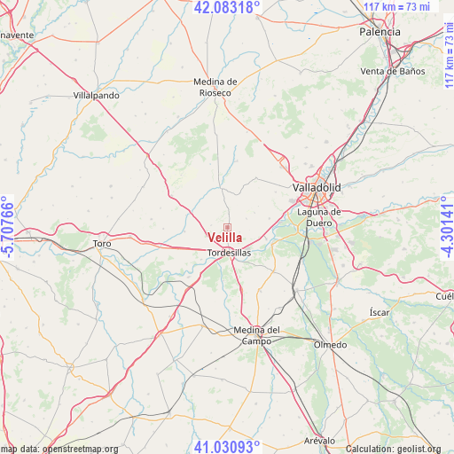
Velilla GPS coordinates[2]
41° 33' 33.12" North, 5° 0' 16.344" West
| Map corner | latitude | longitude |
|---|---|---|
| Upper-left | 42.08318°, | -5.70766° |
| Center: | 41.5592°, | -5.00454° |
| Lower-right: | 41.03093°, | -4.30141° |
| Map W x H: | 117×117 km | = 72.7×72.7mi |
| max Lat: | 43.74134° ⇑37.6% North |
| Velilla: | 41.5592° |
| min Lat: | ⇓62.4% South 27.64134° |
| min Long | Velilla | max Long |
| -18.00367° | -5.00454° | 4.2899° |
| W 27.4%⇐ | ⇒72.6% E |
Elevation
Elevation of Velilla is 785 m = 2575 ft, and this is 187 m = 614 ft above average elevation for this country.
| Max E: |
1682 m = 5518 ft | 33.9% |
| Velilla | 785 m 2575 ft | |
| Avg. | 598 m = 1962 ft | |
Min E: |
0 m = 0 ft | 66.1% |
See also: Spain elevation on elevation.city.
Geographical zone
Velilla is located in North temperate zone (between Tropic of Cancer and the Arctic Circle). Distance of this Northern Tropic circle is 2015 km =1252.1 mi to South.| Distance of | km | miles | from Velilla |
|---|---|---|---|
| North Pole | 5386.1 | 3346.8 | to North |
| Arctic Circle | 2780.2 | 1727.5 | to North |
| Tropic Cancer | 2015 | 1252.1 | to South |
| Equator | 4620.9 | 2871.3 | to South |


Nearby cities:
15 places around Velilla: (largest is in red/bold)
• Bercero
4.3 km =2.7 mi,  277°
277°
• Berceruelo
3.3 km =2.1 mi,  315°
315°
• Castrodeza
10.7 km =6.6 mi,  20°
20°
• Gallegos de Hornija
9.6 km =6 mi,  305°
305°
• Matilla de los Caños
3.3 km =2.1 mi,  111°
111°
• Robladillo
9.6 km =6 mi,  55°
55°
• San Miguel del Pino
9.5 km =5.9 mi,  125°
125°
• San Salvador
9.7 km =6 mi, 314°
• Tordesillas
6.4 km =4 mi,  177°
177°
• Torrecilla de la Abadesa
10.8 km =6.7 mi,  219°
219°
• Torrelobatón
10.2 km =6.3 mi,  350°
350°
• Vega de Valdetronco
9.8 km =6.1 mi,  292°
292°
• Velliza
5.3 km =3.3 mi,  65°
65°
• Villasexmir
10.2 km =6.3 mi,  330°
330°
• Villán de Tordesillas
7.8 km =4.8 mi, 61°
Sources, notices
• [Note1] Compared only with cities in Spain existing in our database
• [Src1] Map data: © OpenStreetMap contributors (CC-BY-SA)
• [Src2] Other city data from geonames.org with taken over terms of usage.
• [Src3] Geographical zone / Annual Mean Temperature by Robert A. Rohde @ Wikipedia
