Tordesillas geodata
Tordesillas (Castille and León) is a seat of a third-order administrative division; located in Spain in Europe/Madrid (GMT+1) time zone. With population of 8,277 people, there are 920 cities with bigger population in this country. Compared to other cities in Spain, 60.9% of cities are located further ↓South; 72.5% of cities are located further →East and 54.6% of cities have lower elevation than Tordesillas. Note1
Administrative division(s):
- Level 1: Castille and León
- Level 2: Provincia de Valladolid
- Level 3: Tordesillas


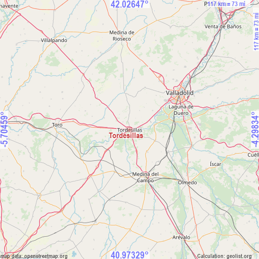
Tordesillas GPS coordinates[2]
41° 30' 7.272" North, 5° 0' 5.256" West
| Map corner | latitude | longitude |
|---|---|---|
| Upper-left | 42.02647°, | -5.70459° |
| Center: | 41.50202°, | -5.00146° |
| Lower-right: | 40.97329°, | -4.29834° |
| Map W x H: | 117.1×117.1 km | = 72.8×72.8mi |
| max Lat: | 43.74134° ⇑39.1% North |
| Tordesillas: | 41.50202° |
| min Lat: | ⇓60.9% South 27.64134° |
| min Long | Tordesillas | max Long |
| -18.00367° | -5.00146° | 4.2899° |
| W 27.5%⇐ | ⇒72.5% E |
Elevation
Elevation of Tordesillas is 705 m = 2313 ft, and this is 107 m = 351 ft above average elevation for this country.
| Max E: |
1682 m = 5518 ft | 45.4% |
| Tordesillas | 705 m 2313 ft | |
| Avg. | 598 m = 1962 ft | |
Min E: |
0 m = 0 ft | 54.6% |
See also: Spain elevation on elevation.city.
Geographical zone
Tordesillas is located in North temperate zone (between Tropic of Cancer and the Arctic Circle). Distance of this Northern Tropic circle is 2008.7 km =1248.1 mi to South.| Distance of | km | miles | from Tordesillas |
|---|---|---|---|
| North Pole | 5392.5 | 3350.7 | to North |
| Arctic Circle | 2786.6 | 1731.5 | to North |
| Tropic Cancer | 2008.7 | 1248.1 | to South |
| Equator | 4614.6 | 2867.4 | to South |


Nearby cities:
15 places around Tordesillas: (largest is in red/bold)
• Bercero
8.2 km =5.1 mi,  326°
326°
• Berceruelo
9.1 km =5.7 mi,  343°
343°
• Geria
13.4 km =8.3 mi,  50°
50°
• La Seca
12.7 km =7.9 mi,  140°
140°
• Matilla de los Caños
5.9 km =3.7 mi,  28°
28°
• Pollos
12.1 km =7.5 mi,  237°
237°
• Rueda
10.6 km =6.6 mi,  160°
160°
• San Miguel del Pino
7.5 km =4.7 mi,  83°
83°
• Serrada
12.6 km =7.8 mi,  113°
113°
• Torrecilla de la Abadesa
7.4 km =4.6 mi,  255°
255°
• Velilla
6.4 km =4 mi,  357°
357°
• Velliza
9.7 km =6 mi, 28°
• Villalar de los Comuneros
12.5 km =7.8 mi,  294°
294°
• Villanueva de Duero
11.4 km =7.1 mi, 80°
• Villán de Tordesillas
12.1 km =7.5 mi, 33°
Sources, notices
• [Note1] Compared only with cities in Spain existing in our database
• [Src1] Map data: © OpenStreetMap contributors (CC-BY-SA)
• [Src2] Other city data from geonames.org with taken over terms of usage.
• [Src3] Geographical zone / Annual Mean Temperature by Robert A. Rohde @ Wikipedia
