Valls geodata
Valls (Catalonia) is a seat of a third-order administrative division; located in Spain in Europe/Madrid (GMT+2) time zone. With population of 25,092 people, there are 373 cities with bigger population in this country. Compared to other cities in Spain, 55.1% of cities are located further ↓South; 91.1% of cities are located further ←West and 79.8% of cities have higher elevation than Valls. Note1


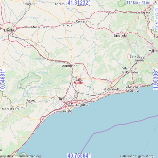
Valls GPS coordinates[2]
41° 17' 10.032" North, 1° 14' 59.748" East
| Map corner | latitude | longitude |
|---|---|---|
| Upper-left | 41.81232°, | 0.54681° |
| Center: | 41.28612°, | 1.24993° |
| Lower-right: | 40.75564°, | 1.95306° |
| Map W x H: | 117.5×117.5 km | = 73×73mi |
| max Lat: | 43.74134° ⇑44.9% North |
| Valls: | 41.28612° |
| min Lat: | ⇓55.1% South 27.64134° |
| min Long | Valls | max Long |
| -18.00367° | 1.24993° | 4.2899° |
| W 91.1%⇐ | ⇒8.9% E |
Elevation
Elevation of Valls is 223 m = 732 ft, and this is 375 m = 1230 ft below average elevation for this country.
| Max E: |
1682 m = 5518 ft | 79.8% |
| Avg. | 598 m = 1962 ft | |
| Valls | 223 m = 732 ft | |
Min E: |
0 m = 0 ft | 20.2% |
See also: Spain elevation on elevation.city.
Geographical zone
Valls is located in North temperate zone (between Tropic of Cancer and the Arctic Circle). Distance of this Northern Tropic circle is 1984.7 km =1233.2 mi to South.| Distance of | km | miles | from Valls |
|---|---|---|---|
| North Pole | 5416.5 | 3365.7 | to North |
| Arctic Circle | 2810.6 | 1746.4 | to North |
| Tropic Cancer | 1984.7 | 1233.2 | to South |
| Equator | 4590.6 | 2852.5 | to South |


Nearby cities:
15 places around Valls: (largest is in red/bold)
• Aiguamúrcia
11.1 km =6.9 mi,  61°
61°
• Alcover
7.2 km =4.5 mi,  248°
248°
• Alió
4.8 km =3 mi,  79°
79°
• Bràfim
7.3 km =4.5 mi,  107°
107°
• El Pla de Santa Maria
9.3 km =5.8 mi,  22°
22°
• La Riba
7.3 km =4.5 mi,  300°
300°
• La Secuita
9.4 km =5.8 mi,  164°
164°
• Montferri
9.9 km =6.2 mi,  103°
103°
• Perafort
10.5 km =6.5 mi,  177°
177°
• Puigpelat
4 km =2.5 mi, 101°
• Renau
8.5 km =5.3 mi,  143°
143°
• Salomó
12.2 km =7.6 mi,  121°
121°
• Vallmoll
4.8 km =3 mi, 180°
• Vilabella
7.9 km =4.9 mi, 122°
• la Pobla de Mafumet
11.8 km =7.3 mi,  193°
193°
Sources, notices
• [Note1] Compared only with cities in Spain existing in our database
• [Src1] Map data: © OpenStreetMap contributors (CC-BY-SA)
• [Src2] Other city data from geonames.org with taken over terms of usage.
• [Src3] Geographical zone / Annual Mean Temperature by Robert A. Rohde @ Wikipedia
