Perafort geodata
Perafort (Catalonia) is a populated place; located in Spain in Europe/Madrid (GMT+2) time zone. With population of 777 people, there are 3257 cities with bigger population in this country. Compared to other cities in Spain, 53% of cities are located further ↓South; 91.2% of cities are located further ←West and 85.9% of cities have higher elevation than Perafort. Note1
Administrative division(s):
- Level 1: Catalonia
- Level 2: Província de Tarragona
- Level 3: els Pallaresos


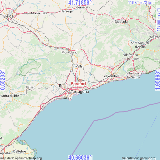
Perafort GPS coordinates[2]
41° 11' 29.796" North, 1° 15' 19.8" East
| Map corner | latitude | longitude |
|---|---|---|
| Upper-left | 41.71858°, | 0.55238° |
| Center: | 41.19161°, | 1.2555° |
| Lower-right: | 40.66036°, | 1.95863° |
| Map W x H: | 117.7×117.7 km | = 73.1×73.1mi |
| max Lat: | 43.74134° ⇑47% North |
| Perafort: | 41.19161° |
| min Lat: | ⇓53% South 27.64134° |
| min Long | Perafort | max Long |
| -18.00367° | 1.2555° | 4.2899° |
| W 91.2%⇐ | ⇒8.8% E |
Elevation
Elevation of Perafort is 125 m = 410 ft, and this is 473 m = 1552 ft below average elevation for this country.
| Max E: |
1682 m = 5518 ft | 85.9% |
| Avg. | 598 m = 1962 ft | |
| Perafort | 125 m = 410 ft | |
Min E: |
0 m = 0 ft | 14.1% |
See also: Spain elevation on elevation.city.
Geographical zone
Perafort is located in North temperate zone (between Tropic of Cancer and the Arctic Circle). Distance of this Northern Tropic circle is 1974.2 km =1226.7 mi to South.| Distance of | km | miles | from Perafort |
|---|---|---|---|
| North Pole | 5427 | 3372.2 | to North |
| Arctic Circle | 2821.1 | 1752.9 | to North |
| Tropic Cancer | 1974.2 | 1226.7 | to South |
| Equator | 4580.1 | 2845.9 | to South |


Nearby cities:
15 places around Perafort: (largest is in red/bold)
• Alcover
10.7 km =6.6 mi,  317°
317°
• Bràfim
10.6 km =6.6 mi,  37°
37°
• Constantí
5.5 km =3.4 mi,  220°
220°
• La Canonja
10 km =6.2 mi, 218°
• La Secuita
2.5 km =1.6 mi,  54°
54°
• La Selva del Camp
10.1 km =6.3 mi,  284°
284°
• Puigpelat
10.3 km =6.4 mi,  19°
19°
• Renau
5.9 km =3.7 mi, 51°
• Tarragona
8.3 km =5.2 mi,  183°
183°
• Vallmoll
5.8 km =3.6 mi,  354°
354°
• Valls
10.5 km =6.5 mi,  357°
357°
• Vilabella
8.8 km =5.5 mi, 45°
• el Catllar
5.8 km =3.6 mi,  118°
118°
• els Pallaresos
2.3 km =1.4 mi,  145°
145°
• la Pobla de Mafumet
3.4 km =2.1 mi,  254°
254°
Sources, notices
• [Note1] Compared only with cities in Spain existing in our database
• [Src1] Map data: © OpenStreetMap contributors (CC-BY-SA)
• [Src2] Other city data from geonames.org with taken over terms of usage.
• [Src3] Geographical zone / Annual Mean Temperature by Robert A. Rohde @ Wikipedia
