la Pobla de Mafumet geodata
la Pobla de Mafumet (Catalonia) is a populated place; located in Spain in Europe/Madrid (GMT+2) time zone. With population of 1,405 people, there are 2537 cities with bigger population in this country. Compared to other cities in Spain, 52.7% of cities are located further ↓South; 91.1% of cities are located further ←West and 89.5% of cities have higher elevation than la Pobla de Mafumet. Note1


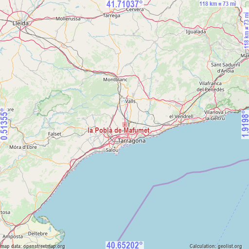
la Pobla de Mafumet GPS coordinates[2]
41° 10' 59.988" North, 1° 13' 0.012" East
| Map corner | latitude | longitude |
|---|---|---|
| Upper-left | 41.71037°, | 0.51355° |
| Center: | 41.18333°, | 1.21667° |
| Lower-right: | 40.65202°, | 1.9198° |
| Map W x H: | 117.7×117.7 km | = 73.1×73.1mi |
| max Lat: | 43.74134° ⇑47.3% North |
| la Pobla de Mafumet: | 41.18333° |
| min Lat: | ⇓52.7% South 27.64134° |
| min Long | la Pobla de Maf | max Long |
| -18.00367° | 1.21667° | 4.2899° |
| W 91.1%⇐ | ⇒8.9% E |
Elevation
Elevation of la Pobla de Mafumet is 74 m = 243 ft, and this is 524 m = 1719 ft below average elevation for this country.
| Max E: |
1682 m = 5518 ft | 89.5% |
| Avg. | 598 m = 1962 ft | |
| la Pobla de Mafumet | 74 m = 243 ft | |
Min E: |
0 m = 0 ft | 10.5% |
See also: Spain elevation on elevation.city.
Geographical zone
la Pobla de Mafumet is located in North temperate zone (between Tropic of Cancer and the Arctic Circle). Distance of this Northern Tropic circle is 1973.2 km =1226.1 mi to South.| Distance of | km | miles | from la Pobla de Mafumet |
|---|---|---|---|
| North Pole | 5427.9 | 3372.7 | to North |
| Arctic Circle | 2822 | 1753.5 | to North |
| Tropic Cancer | 1973.2 | 1226.1 | to South |
| Equator | 4579.2 | 2845.4 | to South |


Nearby cities:
15 places around la Pobla de Mafumet: (largest is in red/bold)
• Alcover
9.6 km =6 mi,  336°
336°
• Almoster
8.9 km =5.5 mi,  280°
280°
• Constantí
3.3 km =2.1 mi,  185°
185°
• La Canonja
7.5 km =4.7 mi,  203°
203°
• La Secuita
5.8 km =3.6 mi,  65°
65°
• La Selva del Camp
7.4 km =4.6 mi,  298°
298°
• Perafort
3.4 km =2.1 mi, 74°
• Renau
9.1 km =5.7 mi,  59°
59°
• Reus
9.7 km =6 mi,  251°
251°
• Tarragona
7.9 km =4.9 mi,  159°
159°
• Vallmoll
7.2 km =4.5 mi,  22°
22°
• Valls
11.8 km =7.3 mi,  13°
13°
• Vila-seca
9.9 km =6.2 mi,  215°
215°
• el Catllar
8.6 km =5.3 mi,  102°
102°
• els Pallaresos
4.6 km =2.9 mi, 101°
Sources, notices
• [Note1] Compared only with cities in Spain existing in our database
• [Src1] Map data: © OpenStreetMap contributors (CC-BY-SA)
• [Src2] Other city data from geonames.org with taken over terms of usage.
• [Src3] Geographical zone / Annual Mean Temperature by Robert A. Rohde @ Wikipedia
