Valdeande geodata
Valdeande (Castille and León) is a seat of a third-order administrative division; located in Spain in Europe/Madrid (GMT+2) time zone. With population of 123 people, there are 5663 cities with bigger population in this country. Compared to other cities in Spain, 69.4% of cities are located further ↓South; 52.6% of cities are located further →East and 85% of cities have lower elevation than Valdeande. Note1
Administrative division(s):
- Level 1: Castille and León
- Level 2: Provincia de Burgos
- Level 3: Valdeande


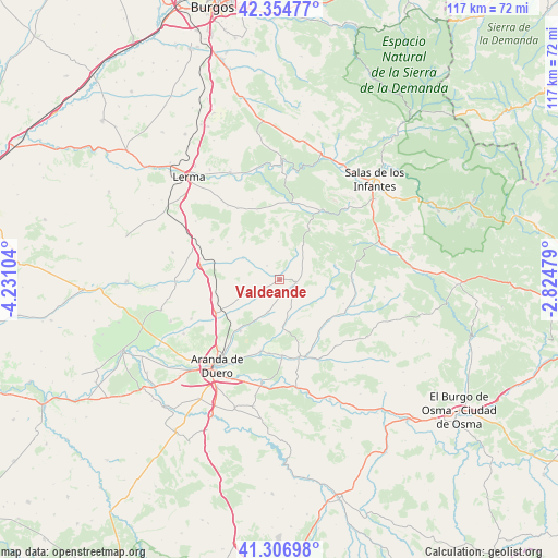
Valdeande GPS coordinates[2]
41° 49' 58.872" North, 3° 31' 40.512" West
| Map corner | latitude | longitude |
|---|---|---|
| Upper-left | 42.35477°, | -4.23104° |
| Center: | 41.83302°, | -3.52792° |
| Lower-right: | 41.30698°, | -2.82479° |
| Map W x H: | 116.5×116.5 km | = 72.4×72.4mi |
| max Lat: | 43.74134° ⇑30.6% North |
| Valdeande: | 41.83302° |
| min Lat: | ⇓69.4% South 27.64134° |
| min Long | Valdeande | max Long |
| -18.00367° | -3.52792° | 4.2899° |
| W 47.4%⇐ | ⇒52.6% E |
Elevation
Elevation of Valdeande is 951 m = 3120 ft, and this is 353 m = 1158 ft above average elevation for this country.
| Max E: |
1682 m = 5518 ft | 15% |
| Valdeande | 951 m 3120 ft | |
| Avg. | 598 m = 1962 ft | |
Min E: |
0 m = 0 ft | 85% |
See also: Spain elevation on elevation.city.
Geographical zone
Valdeande is located in North temperate zone (between Tropic of Cancer and the Arctic Circle). Distance of this Northern Tropic circle is 2045.5 km =1271 mi to South.| Distance of | km | miles | from Valdeande |
|---|---|---|---|
| North Pole | 5355.7 | 3327.9 | to North |
| Arctic Circle | 2749.8 | 1708.6 | to North |
| Tropic Cancer | 2045.5 | 1271 | to South |
| Equator | 4651.4 | 2890.2 | to South |


Nearby cities:
15 places around Valdeande: (largest is in red/bold)
• Arandilla
13.4 km =8.3 mi,  142°
142°
• Arauzo de Miel
12 km =7.5 mi,  76°
76°
• Arauzo de Salce
9.7 km =6 mi,  99°
99°
• Arauzo de Torre
9.5 km =5.9 mi,  114°
114°
• Baños de Valdearados
7.4 km =4.6 mi,  198°
198°
• Caleruega
3.6 km =2.2 mi, 103°
• Cilleruelo de Arriba
13.6 km =8.5 mi,  305°
305°
• Ciruelos de Cervera
8.1 km =5 mi,  358°
358°
• Coruña del Conde
13.6 km =8.5 mi,  123°
123°
• Espinosa de Cervera
8.6 km =5.3 mi,  34°
34°
• Hontoria de Valdearados
9.8 km =6.1 mi,  176°
176°
• Tejada
13.3 km =8.3 mi, 357°
• Tubilla del Lago
6 km =3.7 mi,  234°
234°
• Villalbilla de Gumiel
8.6 km =5.3 mi,  249°
249°
• Villanueva de Gumiel
13.4 km =8.3 mi,  217°
217°
Sources, notices
• [Note1] Compared only with cities in Spain existing in our database
• [Src1] Map data: © OpenStreetMap contributors (CC-BY-SA)
• [Src2] Other city data from geonames.org with taken over terms of usage.
• [Src3] Geographical zone / Annual Mean Temperature by Robert A. Rohde @ Wikipedia
