Tejada geodata
Tejada (Castille and León) is a seat of a third-order administrative division; located in Spain in Europe/Madrid (GMT+2) time zone. With population of 41 people, there are 6557 cities with bigger population in this country. Compared to other cities in Spain, 72.4% of cities are located further ↓South; 52.8% of cities are located further →East and 92.8% of cities have lower elevation than Tejada. Note1


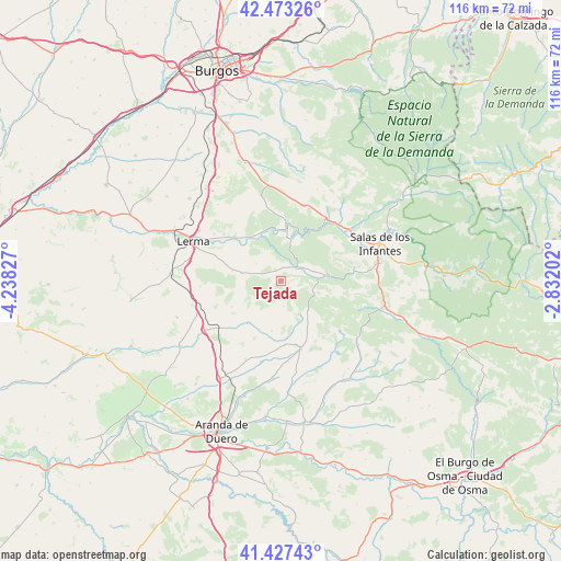
Tejada GPS coordinates[2]
41° 57' 8.964" North, 3° 32' 6.504" West
| Map corner | latitude | longitude |
|---|---|---|
| Upper-left | 42.47326°, | -4.23827° |
| Center: | 41.95249°, | -3.53514° |
| Lower-right: | 41.42743°, | -2.83202° |
| Map W x H: | 116.3×116.3 km | = 72.3×72.3mi |
| max Lat: | 43.74134° ⇑27.6% North |
| Tejada: | 41.95249° |
| min Lat: | ⇓72.4% South 27.64134° |
| min Long | Tejada | max Long |
| -18.00367° | -3.53514° | 4.2899° |
| W 47.2%⇐ | ⇒52.8% E |
Elevation
Elevation of Tejada is 1086 m = 3563 ft, and this is 488 m = 1601 ft above average elevation for this country.
| Max E: |
1682 m = 5518 ft | 7.2% |
| Tejada | 1086 m 3563 ft | |
| Avg. | 598 m = 1962 ft | |
Min E: |
0 m = 0 ft | 92.8% |
See also: Spain elevation on elevation.city.
Geographical zone
Tejada is located in North temperate zone (between Tropic of Cancer and the Arctic Circle). Distance of this Northern Tropic circle is 2058.8 km =1279.3 mi to South.| Distance of | km | miles | from Tejada |
|---|---|---|---|
| North Pole | 5342.4 | 3319.6 | to North |
| Arctic Circle | 2736.5 | 1700.4 | to North |
| Tropic Cancer | 2058.8 | 1279.3 | to South |
| Equator | 4664.7 | 2898.5 | to South |


Nearby cities:
15 places around Tejada: (largest is in red/bold)
• Cebrecos
6.2 km =3.9 mi,  304°
304°
• Cilleruelo de Arriba
11.7 km =7.3 mi,  243°
243°
• Ciruelos de Cervera
5.2 km =3.2 mi,  175°
175°
• Contreras
12.7 km =7.9 mi,  53°
53°
• Covarrubias
11.9 km =7.4 mi,  6°
6°
• Espinosa de Cervera
8.3 km =5.2 mi,  138°
138°
• Mamolar
14.6 km =9.1 mi,  100°
100°
• Nebreda
8.4 km =5.2 mi,  282°
282°
• Puentedura
10.6 km =6.6 mi,  338°
338°
• Quintanilla del Coco
3.8 km =2.4 mi,  24°
24°
• Retuerta
8.9 km =5.5 mi, 15°
• Santibáñez del Val
5 km =3.1 mi,  62°
62°
• Santo Domingo de Silos
9.8 km =6.1 mi,  82°
82°
• Solarana
10.4 km =6.5 mi, 281°
• Valdeande
13.3 km =8.3 mi, 177°
Sources, notices
• [Note1] Compared only with cities in Spain existing in our database
• [Src1] Map data: © OpenStreetMap contributors (CC-BY-SA)
• [Src2] Other city data from geonames.org with taken over terms of usage.
• [Src3] Geographical zone / Annual Mean Temperature by Robert A. Rohde @ Wikipedia
