Todolella geodata
Todolella (Valencia) is a seat of a third-order administrative division; located in Spain in Europe/Madrid (GMT+2) time zone. With population of 133 people, there are 5556 cities with bigger population in this country. Compared to other cities in Spain, 58.9% of cities are located further ↑North; 85.2% of cities are located further ←West and 68.4% of cities have lower elevation than Todolella. Note1


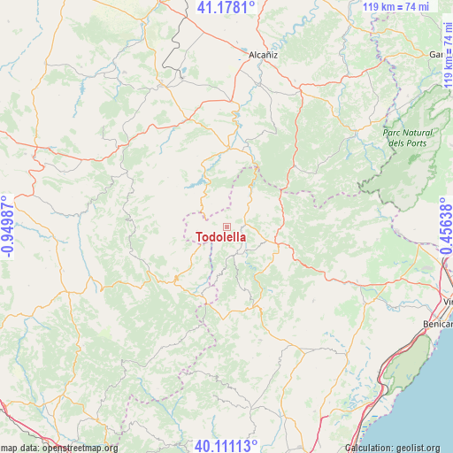
Todolella GPS coordinates[2]
40° 38' 48.3" North, 0° 14' 48.3" West
| Map corner | latitude | longitude |
|---|---|---|
| Upper-left | 41.1781°, | -0.94987° |
| Center: | 40.64675°, | -0.24675° |
| Lower-right: | 40.11113°, | 0.45638° |
| Map W x H: | 118.6×118.6 km | = 73.7×73.7mi |
| max Lat: | 43.74134° ⇑58.9% North |
| Todolella: | 40.64675° |
| min Lat: | ⇓41.1% South 27.64134° |
| min Long | Todolella | max Long |
| -18.00367° | -0.24675° | 4.2899° |
| W 85.2%⇐ | ⇒14.8% E |
Elevation
Elevation of Todolella is 801 m = 2628 ft, and this is 203 m = 666 ft above average elevation for this country.
| Max E: |
1682 m = 5518 ft | 31.6% |
| Todolella | 801 m 2628 ft | |
| Avg. | 598 m = 1962 ft | |
Min E: |
0 m = 0 ft | 68.4% |
See also: Spain elevation on elevation.city.
Geographical zone
Todolella is located in North temperate zone (between Tropic of Cancer and the Arctic Circle). Distance of this Northern Tropic circle is 1913.6 km =1189.1 mi to South.| Distance of | km | miles | from Todolella |
|---|---|---|---|
| North Pole | 5487.6 | 3409.8 | to North |
| Arctic Circle | 2881.7 | 1790.6 | to North |
| Tropic Cancer | 1913.6 | 1189.1 | to South |
| Equator | 4519.5 | 2808.3 | to South |


Nearby cities:
15 places around Todolella: (largest is in red/bold)
• Bordón
7.7 km =4.8 mi,  304°
304°
• Cantavieja
18.9 km =11.7 mi,  225°
225°
• Castellfort
16.8 km =10.4 mi,  163°
163°
• Castellote
18.1 km =11.2 mi,  340°
340°
• Cinctorres
7.5 km =4.7 mi, 160°
• Forcall
4 km =2.5 mi,  92°
92°
• Mirambel
10.4 km =6.5 mi, 230°
• Morella
12.8 km =8 mi,  103°
103°
• Olocau del Rey
8 km =5 mi,  262°
262°
• Palanques
9.7 km =6 mi,  35°
35°
• Portell de Morella
12.8 km =8 mi,  185°
185°
• Torre de Arcas
19 km =11.8 mi,  52°
52°
• Tronchón
13.1 km =8.1 mi, 257°
• Villores
5 km =3.1 mi, 51°
• Zorita del Maestrazgo
11.3 km =7 mi, 36°
Sources, notices
• [Note1] Compared only with cities in Spain existing in our database
• [Src1] Map data: © OpenStreetMap contributors (CC-BY-SA)
• [Src2] Other city data from geonames.org with taken over terms of usage.
• [Src3] Geographical zone / Annual Mean Temperature by Robert A. Rohde @ Wikipedia
