Torrubia geodata
Torrubia (Castille-La Mancha) is a seat of a third-order administrative division; located in Spain in Europe/Madrid (GMT+2) time zone. With population of 39 people, there are 6576 cities with bigger population in this country. Compared to other cities in Spain, 52.4% of cities are located further ↑North; 68.4% of cities are located further ←West and 96.1% of cities have lower elevation than Torrubia. Note1
Administrative division(s):
- Level 1: Castille-La Mancha
- Level 2: Provincia de Guadalajara
- Level 3: Torrubia


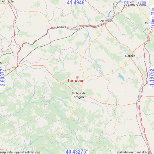
Torrubia GPS coordinates[2]
40° 57' 56.916" North, 1° 54' 2.304" West
| Map corner | latitude | longitude |
|---|---|---|
| Upper-left | 41.4946°, | -2.60377° |
| Center: | 40.96581°, | -1.90064° |
| Lower-right: | 40.43275°, | -1.19752° |
| Map W x H: | 118.1×118.1 km | = 73.4×73.4mi |
| max Lat: | 43.74134° ⇑52.4% North |
| Torrubia: | 40.96581° |
| min Lat: | ⇓47.6% South 27.64134° |
| min Long | Torrubia | max Long |
| -18.00367° | -1.90064° | 4.2899° |
| W 68.4%⇐ | ⇒31.6% E |
Elevation
Elevation of Torrubia is 1173 m = 3848 ft, and this is 575 m = 1886 ft above average elevation for this country.
| Max E: |
1682 m = 5518 ft | 3.9% |
| Torrubia | 1173 m 3848 ft | |
| Avg. | 598 m = 1962 ft | |
Min E: |
0 m = 0 ft | 96.1% |
See also: Spain elevation on elevation.city.
Geographical zone
Torrubia is located in North temperate zone (between Tropic of Cancer and the Arctic Circle). Distance of this Northern Tropic circle is 1949.1 km =1211.1 mi to South.| Distance of | km | miles | from Torrubia |
|---|---|---|---|
| North Pole | 5452.1 | 3387.8 | to North |
| Arctic Circle | 2846.2 | 1768.5 | to North |
| Tropic Cancer | 1949.1 | 1211.1 | to South |
| Equator | 4555 | 2830.3 | to South |


Nearby cities:
15 places around Torrubia: (largest is in red/bold)
• Castilnuevo
17.2 km =10.7 mi,  167°
167°
• Corduente
15.1 km =9.4 mi,  205°
205°
• Embid
15.9 km =9.9 mi,  87°
87°
• Establés
11.4 km =7.1 mi,  294°
294°
• Fuentelsaz
13.3 km =8.3 mi,  25°
25°
• Herrería
10 km =6.2 mi, 210°
• Milmarcos
13.5 km =8.4 mi,  8°
8°
• Molina de Aragón
13.6 km =8.5 mi,  175°
175°
• Pardos
2.9 km =1.8 mi,  226°
226°
• Rillo de Gallo
11.5 km =7.1 mi,  195°
195°
• Rueda de la Sierra
6.6 km =4.1 mi,  143°
143°
• Selas
17 km =10.6 mi,  264°
264°
• Tartanedo
3.7 km =2.3 mi,  326°
326°
• Torremocha del Pinar
14.8 km =9.2 mi,  235°
235°
• Tortuera
8.7 km =5.4 mi, 85°
Sources, notices
• [Note1] Compared only with cities in Spain existing in our database
• [Src1] Map data: © OpenStreetMap contributors (CC-BY-SA)
• [Src2] Other city data from geonames.org with taken over terms of usage.
• [Src3] Geographical zone / Annual Mean Temperature by Robert A. Rohde @ Wikipedia
