Castilnuevo geodata
Castilnuevo (Castille-La Mancha) is a seat of a third-order administrative division; located in Spain in Europe/Madrid (GMT+2) time zone. With population of 11 people, there are 6756 cities with bigger population in this country. Compared to other cities in Spain, 55.8% of cities are located further ↑North; 68.9% of cities are located further ←West and 92.7% of cities have lower elevation than Castilnuevo. Note1
Administrative division(s):
- Level 1: Castille-La Mancha
- Level 2: Provincia de Guadalajara
- Level 3: Castilnuevo


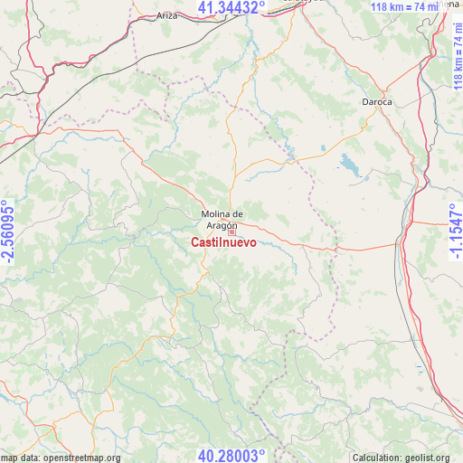
Castilnuevo GPS coordinates[2]
40° 48' 51.516" North, 1° 51' 28.152" West
| Map corner | latitude | longitude |
|---|---|---|
| Upper-left | 41.34432°, | -2.56095° |
| Center: | 40.81431°, | -1.85782° |
| Lower-right: | 40.28003°, | -1.1547° |
| Map W x H: | 118.3×118.3 km | = 73.5×73.5mi |
| max Lat: | 43.74134° ⇑55.8% North |
| Castilnuevo: | 40.81431° |
| min Lat: | ⇓44.2% South 27.64134° |
| min Long | Castilnuevo | max Long |
| -18.00367° | -1.85782° | 4.2899° |
| W 68.9%⇐ | ⇒31.1% E |
Elevation
Elevation of Castilnuevo is 1085 m = 3560 ft, and this is 487 m = 1598 ft above average elevation for this country.
| Max E: |
1682 m = 5518 ft | 7.3% |
| Castilnuevo | 1085 m 3560 ft | |
| Avg. | 598 m = 1962 ft | |
Min E: |
0 m = 0 ft | 92.7% |
See also: Spain elevation on elevation.city.
Geographical zone
Castilnuevo is located in North temperate zone (between Tropic of Cancer and the Arctic Circle). Distance of this Northern Tropic circle is 1932.2 km =1200.6 mi to South.| Distance of | km | miles | from Castilnuevo |
|---|---|---|---|
| North Pole | 5468.9 | 3398.2 | to North |
| Arctic Circle | 2863 | 1779 | to North |
| Tropic Cancer | 1932.2 | 1200.6 | to South |
| Equator | 4538.1 | 2819.8 | to South |


Nearby cities:
15 places around Castilnuevo: (largest is in red/bold)
• Anquela del Pedregal
12.9 km =8 mi,  127°
127°
• Castellar de la Muela
8.3 km =5.2 mi,  86°
86°
• Corduente
10.6 km =6.6 mi,  287°
287°
• Fuembellida
13.5 km =8.4 mi,  241°
241°
• Herrería
11.9 km =7.4 mi,  313°
313°
• Molina de Aragón
4.1 km =2.5 mi,  322°
322°
• Morenilla
13 km =8.1 mi,  103°
103°
• Prados Redondos
6.3 km =3.9 mi,  120°
120°
• Rillo de Gallo
8.8 km =5.5 mi, 310°
• Rueda de la Sierra
11.5 km =7.1 mi,  1°
1°
• Terzaga
13.8 km =8.6 mi,  196°
196°
• Tierzo
9.5 km =5.9 mi,  220°
220°
• Torrecuadrada de Molina
8.4 km =5.2 mi,  149°
149°
• Torremochuela
5.6 km =3.5 mi,  166°
166°
• Valhermoso
9.3 km =5.8 mi,  250°
250°
Sources, notices
• [Note1] Compared only with cities in Spain existing in our database
• [Src1] Map data: © OpenStreetMap contributors (CC-BY-SA)
• [Src2] Other city data from geonames.org with taken over terms of usage.
• [Src3] Geographical zone / Annual Mean Temperature by Robert A. Rohde @ Wikipedia
