Establés geodata
Establés (Castille-La Mancha) is a seat of a third-order administrative division; located in Spain in Europe/Madrid (GMT+2) time zone. With population of 52 people, there are 6440 cities with bigger population in this country. Compared to other cities in Spain, 51.4% of cities are located further ↑North; 67.2% of cities are located further ←West and 95.4% of cities have lower elevation than Establés. Note1
Administrative division(s):
- Level 1: Castille-La Mancha
- Level 2: Provincia de Guadalajara
- Level 3: Establés


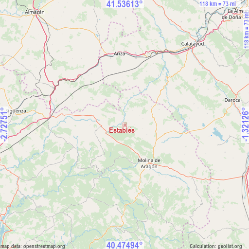
Establés GPS coordinates[2]
41° 0' 27.612" North, 2° 1' 27.768" West
| Map corner | latitude | longitude |
|---|---|---|
| Upper-left | 41.53613°, | -2.72751° |
| Center: | 41.00767°, | -2.02438° |
| Lower-right: | 40.47494°, | -1.32126° |
| Map W x H: | 118×118 km | = 73.3×73.3mi |
| max Lat: | 43.74134° ⇑51.4% North |
| Establés: | 41.00767° |
| min Lat: | ⇓48.6% South 27.64134° |
| min Long | Establés | max Long |
| -18.00367° | -2.02438° | 4.2899° |
| W 67.2%⇐ | ⇒32.8% E |
Elevation
Elevation of Establés is 1148 m = 3766 ft, and this is 550 m = 1804 ft above average elevation for this country.
| Max E: |
1682 m = 5518 ft | 4.6% |
| Establés | 1148 m 3766 ft | |
| Avg. | 598 m = 1962 ft | |
Min E: |
0 m = 0 ft | 95.4% |
See also: Spain elevation on elevation.city.
Geographical zone
Establés is located in North temperate zone (between Tropic of Cancer and the Arctic Circle). Distance of this Northern Tropic circle is 1953.7 km =1214 mi to South.| Distance of | km | miles | from Establés |
|---|---|---|---|
| North Pole | 5447.4 | 3384.9 | to North |
| Arctic Circle | 2841.5 | 1765.6 | to North |
| Tropic Cancer | 1953.7 | 1214 | to South |
| Equator | 4559.6 | 2833.2 | to South |


Nearby cities:
15 places around Establés: (largest is in red/bold)
• Algar de Mesa
15.2 km =9.4 mi,  20°
20°
• Anquela del Ducado
9.8 km =6.1 mi,  245°
245°
• Herrería
14.3 km =8.9 mi,  157°
157°
• Maranchón
15.8 km =9.8 mi,  286°
286°
• Mazarete
11.3 km =7 mi,  266°
266°
• Milmarcos
15.2 km =9.4 mi,  54°
54°
• Mochales
9.9 km =6.2 mi,  4°
4°
• Pardos
10.6 km =6.6 mi,  128°
128°
• Rillo de Gallo
17.3 km =10.7 mi, 155°
• Rueda de la Sierra
17.4 km =10.8 mi,  124°
124°
• Selas
9 km =5.6 mi,  226°
226°
• Tartanedo
8.5 km =5.3 mi,  100°
100°
• Torremocha del Pinar
13.2 km =8.2 mi,  187°
187°
• Torrubia
11.4 km =7.1 mi,  114°
114°
• Villel de Mesa
13.5 km =8.4 mi,  12°
12°
Sources, notices
• [Note1] Compared only with cities in Spain existing in our database
• [Src1] Map data: © OpenStreetMap contributors (CC-BY-SA)
• [Src2] Other city data from geonames.org with taken over terms of usage.
• [Src3] Geographical zone / Annual Mean Temperature by Robert A. Rohde @ Wikipedia
