Torralba geodata
Torralba (Castille-La Mancha) is a seat of a third-order administrative division; located in Spain in Europe/Madrid (GMT+2) time zone. With population of 181 people, there are 5181 cities with bigger population in this country. Compared to other cities in Spain, 65.7% of cities are located further ↑North; 63.6% of cities are located further ←West and 81.3% of cities have lower elevation than Torralba. Note1
Administrative division(s):
- Level 1: Castille-La Mancha
- Level 2: Provincia de Cuenca
- Level 3: Torralba


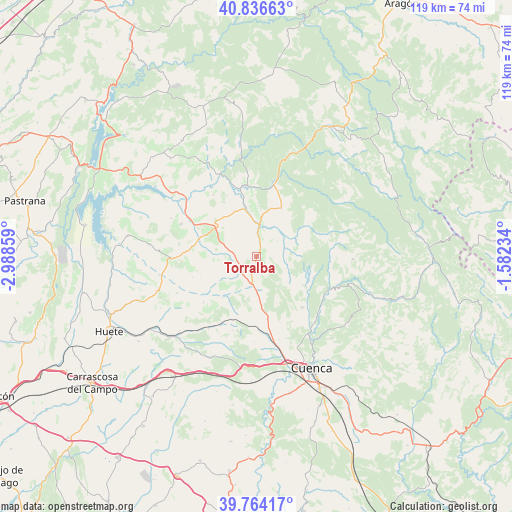
Torralba GPS coordinates[2]
40° 18' 9.108" North, 2° 17' 7.656" West
| Map corner | latitude | longitude |
|---|---|---|
| Upper-left | 40.83663°, | -2.98859° |
| Center: | 40.30253°, | -2.28546° |
| Lower-right: | 39.76417°, | -1.58234° |
| Map W x H: | 119.2×119.2 km | = 74.1×74.1mi |
| max Lat: | 43.74134° ⇑65.7% North |
| Torralba: | 40.30253° |
| min Lat: | ⇓34.3% South 27.64134° |
| min Long | Torralba | max Long |
| -18.00367° | -2.28546° | 4.2899° |
| W 63.6%⇐ | ⇒36.4% E |
Elevation
Elevation of Torralba is 910 m = 2986 ft, and this is 312 m = 1024 ft above average elevation for this country.
| Max E: |
1682 m = 5518 ft | 18.7% |
| Torralba | 910 m 2986 ft | |
| Avg. | 598 m = 1962 ft | |
Min E: |
0 m = 0 ft | 81.3% |
See also: Spain elevation on elevation.city.
Geographical zone
Torralba is located in North temperate zone (between Tropic of Cancer and the Arctic Circle). Distance of this Northern Tropic circle is 1875.3 km =1165.3 mi to South.| Distance of | km | miles | from Torralba |
|---|---|---|---|
| North Pole | 5525.8 | 3433.6 | to North |
| Arctic Circle | 2920 | 1814.4 | to North |
| Tropic Cancer | 1875.3 | 1165.3 | to South |
| Equator | 4481.2 | 2784.5 | to South |


Nearby cities:
15 places around Torralba: (largest is in red/bold)
• Albalate de las Nogueras
7.1 km =4.4 mi,  5°
5°
• Arcos de la Sierra
15.4 km =9.6 mi,  71°
71°
• Arrancacepas
6.2 km =3.9 mi,  270°
270°
• Bascuñana de San Pedro
11.1 km =6.9 mi,  153°
153°
• Buciegas
15.5 km =9.6 mi,  284°
284°
• Castillejo-Sierra
14.7 km =9.1 mi,  56°
56°
• Castillo-Albaráñez
9.1 km =5.7 mi, 267°
• Cañaveras
11.3 km =7 mi,  304°
304°
• Fresneda de la Sierra
15.6 km =9.7 mi,  50°
50°
• La Frontera
12.5 km =7.8 mi,  27°
27°
• Olmeda de la Cuesta
16.2 km =10.1 mi, 273°
• Olmedilla de Eliz
11.4 km =7.1 mi, 269°
• Villaconejos de Trabaque
11.3 km =7 mi,  345°
345°
• Villar de Domingo García
7.3 km =4.5 mi,  183°
183°
• Zarzuela
15.6 km =9.7 mi,  108°
108°
Sources, notices
• [Note1] Compared only with cities in Spain existing in our database
• [Src1] Map data: © OpenStreetMap contributors (CC-BY-SA)
• [Src2] Other city data from geonames.org with taken over terms of usage.
• [Src3] Geographical zone / Annual Mean Temperature by Robert A. Rohde @ Wikipedia
