Torelló geodata
Torelló (Catalonia) is a populated place; located in Spain in Europe/Madrid (GMT+2) time zone. With population of 13,808 people, there are 674 cities with bigger population in this country. Compared to other cities in Spain, 75% of cities are located further ↓South; 95.7% of cities are located further ←West and 60.8% of cities have higher elevation than Torelló. Note1


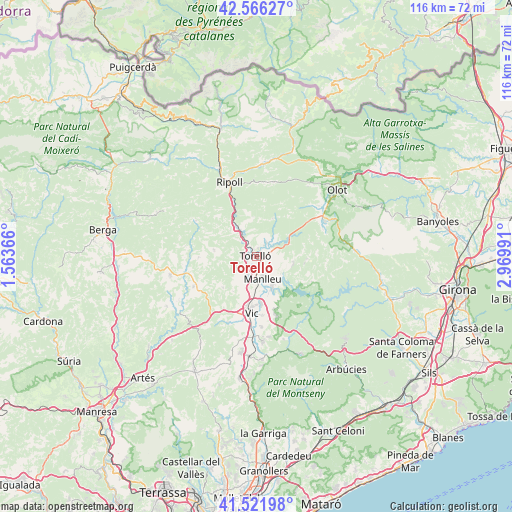
Torelló GPS coordinates[2]
42° 2' 46.572" North, 2° 16' 0.444" East
| Map corner | latitude | longitude |
|---|---|---|
| Upper-left | 42.56627°, | 1.56366° |
| Center: | 42.04627°, | 2.26679° |
| Lower-right: | 41.52198°, | 2.96991° |
| Map W x H: | 116.1×116.1 km | = 72.1×72.1mi |
| max Lat: | 43.74134° ⇑25% North |
| Torelló: | 42.04627° |
| min Lat: | ⇓75% South 27.64134° |
| min Long | Torelló | max Long |
| -18.00367° | 2.26679° | 4.2899° |
| W 95.7%⇐ | ⇒4.3% E |
Elevation
Elevation of Torelló is 517 m = 1696 ft, and this is 81 m = 266 ft below average elevation for this country.
| Max E: |
1682 m = 5518 ft | 60.8% |
| Avg. | 598 m = 1962 ft | |
| Torelló | 517 m = 1696 ft | |
Min E: |
0 m = 0 ft | 39.2% |
See also: Spain elevation on elevation.city.
Geographical zone
Torelló is located in North temperate zone (between Tropic of Cancer and the Arctic Circle). Distance of this Northern Tropic circle is 2069.2 km =1285.7 mi to South.| Distance of | km | miles | from Torelló |
|---|---|---|---|
| North Pole | 5332 | 3313.2 | to North |
| Arctic Circle | 2726.1 | 1693.9 | to North |
| Tropic Cancer | 2069.2 | 1285.7 | to South |
| Equator | 4675.1 | 2905 | to South |


Nearby cities:
15 places around Torelló: (largest is in red/bold)
• Gurb
10.6 km =6.6 mi,  194°
194°
• Manlleu
5.1 km =3.2 mi,  163°
163°
• Montesquiu
8.9 km =5.5 mi,  332°
332°
• Olost
15.8 km =9.8 mi,  244°
244°
• Orís
4.1 km =2.5 mi,  291°
291°
• Sant Boi de Lluçanès
9.7 km =6 mi,  272°
272°
• Sant Julià de Vilatorta
14.6 km =9.1 mi, 160°
• Santa Cecília de Voltregà
5.8 km =3.6 mi,  208°
208°
• Santa Maria de Corcó
8.4 km =5.2 mi,  99°
99°
• Sora
11.4 km =7.1 mi,  310°
310°
• Tavertet
13.7 km =8.5 mi,  114°
114°
• Vic
13 km =8.1 mi,  184°
184°
• Vidrà
9.2 km =5.7 mi,  22°
22°
• Vilanova de Sau
14.7 km =9.1 mi,  138°
138°
• Vilaseca
2 km =1.2 mi, 331°
Sources, notices
• [Note1] Compared only with cities in Spain existing in our database
• [Src1] Map data: © OpenStreetMap contributors (CC-BY-SA)
• [Src2] Other city data from geonames.org with taken over terms of usage.
• [Src3] Geographical zone / Annual Mean Temperature by Robert A. Rohde @ Wikipedia
