Olost geodata
Olost (Catalonia) is a populated place; located in Spain in Europe/Madrid (GMT+2) time zone. With population of 1,187 people, there are 2732 cities with bigger population in this country. Compared to other cities in Spain, 73.4% of cities are located further ↓South; 93.8% of cities are located further ←West and 56.6% of cities have higher elevation than Olost. Note1


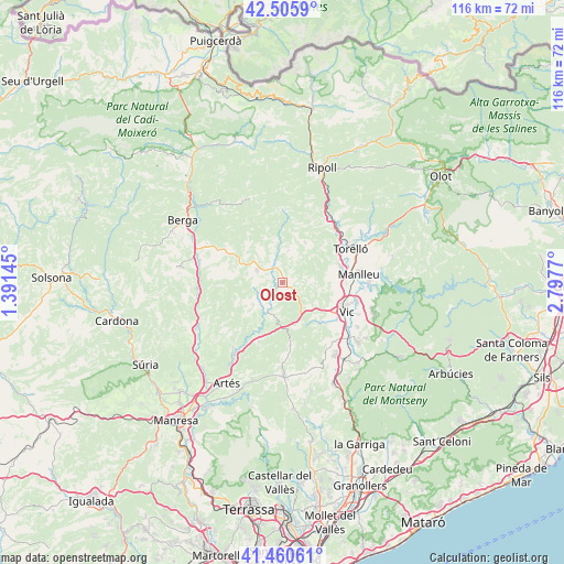
Olost GPS coordinates[2]
41° 59' 7.44" North, 2° 5' 40.452" East
| Map corner | latitude | longitude |
|---|---|---|
| Upper-left | 42.5059°, | 1.39145° |
| Center: | 41.9854°, | 2.09457° |
| Lower-right: | 41.46061°, | 2.7977° |
| Map W x H: | 116.2×116.2 km | = 72.2×72.2mi |
| max Lat: | 43.74134° ⇑26.6% North |
| Olost: | 41.9854° |
| min Lat: | ⇓73.4% South 27.64134° |
| min Long | Olost | max Long |
| -18.00367° | 2.09457° | 4.2899° |
| W 93.8%⇐ | ⇒6.2% E |
Elevation
Elevation of Olost is 572 m = 1877 ft, and this is 26 m = 85 ft below average elevation for this country.
| Max E: |
1682 m = 5518 ft | 56.6% |
| Avg. | 598 m = 1962 ft | |
| Olost | 572 m = 1877 ft | |
Min E: |
0 m = 0 ft | 43.4% |
See also: Spain elevation on elevation.city.
Geographical zone
Olost is located in North temperate zone (between Tropic of Cancer and the Arctic Circle). Distance of this Northern Tropic circle is 2062.4 km =1281.5 mi to South.| Distance of | km | miles | from Olost |
|---|---|---|---|
| North Pole | 5338.7 | 3317.3 | to North |
| Arctic Circle | 2732.8 | 1698.1 | to North |
| Tropic Cancer | 2062.4 | 1281.5 | to South |
| Equator | 4668.3 | 2900.7 | to South |


Nearby cities:
15 places around Olost: (largest is in red/bold)
• Alpens
14.9 km =9.3 mi,  2°
2°
• Gurb
12.1 km =7.5 mi,  106°
106°
• Muntanyola
13.5 km =8.4 mi,  147°
147°
• Oristà
6.2 km =3.9 mi,  201°
201°
• Orís
13.3 km =8.3 mi,  51°
51°
• Prats de Lluçanès
6.1 km =3.8 mi,  304°
304°
• Sagàs
12.8 km =8 mi, 304°
• Sant Boi de Lluçanès
8.5 km =5.3 mi,  32°
32°
• Sant Feliu Sasserra
6.4 km =4 mi,  232°
232°
• Sant Maurici de la Quar
15.2 km =9.4 mi,  315°
315°
• Santa Cecília de Voltregà
11.6 km =7.2 mi,  81°
81°
• Santa Eulàlia de Riuprimer
11.4 km =7.1 mi,  136°
136°
• Santa Maria d'Oló
14.1 km =8.8 mi, 200°
• Sora
15.1 km =9.4 mi,  21°
21°
• Vic
14.6 km =9.1 mi, 114°
Sources, notices
• [Note1] Compared only with cities in Spain existing in our database
• [Src1] Map data: © OpenStreetMap contributors (CC-BY-SA)
• [Src2] Other city data from geonames.org with taken over terms of usage.
• [Src3] Geographical zone / Annual Mean Temperature by Robert A. Rohde @ Wikipedia
