Tábara geodata
Tábara (Castille and León) is a seat of a third-order administrative division; located in Spain in Europe/Madrid (GMT+2) time zone. With population of 931 people, there are 3037 cities with bigger population in this country. Compared to other cities in Spain, 69.2% of cities are located further ↓South; 85.5% of cities are located further →East and 61.5% of cities have lower elevation than Tábara. Note1


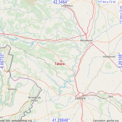
Tábara GPS coordinates[2]
41° 49' 28.488" North, 5° 57' 51.12" West
| Map corner | latitude | longitude |
|---|---|---|
| Upper-left | 42.3464°, | -6.66733° |
| Center: | 41.82458°, | -5.9642° |
| Lower-right: | 41.29848°, | -5.26108° |
| Map W x H: | 116.5×116.5 km | = 72.4×72.4mi |
| max Lat: | 43.74134° ⇑30.8% North |
| Tábara: | 41.82458° |
| min Lat: | ⇓69.2% South 27.64134° |
| min Long | Tábara | max Long |
| -18.00367° | -5.9642° | 4.2899° |
| W 14.5%⇐ | ⇒85.5% E |
Elevation
Elevation of Tábara is 754 m = 2474 ft, and this is 156 m = 512 ft above average elevation for this country.
| Max E: |
1682 m = 5518 ft | 38.5% |
| Tábara | 754 m 2474 ft | |
| Avg. | 598 m = 1962 ft | |
Min E: |
0 m = 0 ft | 61.5% |
See also: Spain elevation on elevation.city.
Geographical zone
Tábara is located in North temperate zone (between Tropic of Cancer and the Arctic Circle). Distance of this Northern Tropic circle is 2044.5 km =1270.4 mi to South.| Distance of | km | miles | from Tábara |
|---|---|---|---|
| North Pole | 5356.6 | 3328.4 | to North |
| Arctic Circle | 2750.7 | 1709.2 | to North |
| Tropic Cancer | 2044.5 | 1270.4 | to South |
| Equator | 4650.5 | 2889.7 | to South |


Nearby cities:
15 places around Tábara: (largest is in red/bold)
• Faramontanos de Tábara
6.3 km =3.9 mi,  79°
79°
• Ferreras de Abajo
12.4 km =7.7 mi,  310°
310°
• Ferreruela
11 km =6.8 mi,  234°
234°
• Friera de Valverde
14.1 km =8.8 mi,  46°
46°
• Losacio
14.1 km =8.8 mi,  206°
206°
• Melgar de Tera
16.3 km =10.1 mi,  345°
345°
• Morales de Valverde
13.8 km =8.6 mi,  25°
25°
• Moreruela de Tábara
8.5 km =5.3 mi,  111°
111°
• Olmillos de Castro
10.3 km =6.4 mi,  181°
181°
• Perilla de Castro
13.2 km =8.2 mi,  146°
146°
• Pozuelo de Tábara
7.3 km =4.5 mi,  127°
127°
• Pueblica de Valverde
11.7 km =7.3 mi, 27°
• Santa María de Valverde
12.5 km =7.8 mi,  10°
10°
• Villanueva de las Peras
12.3 km =7.6 mi, 354°
• Villaveza de Valverde
16.5 km =10.3 mi,  35°
35°
Sources, notices
• [Note1] Compared only with cities in Spain existing in our database
• [Src1] Map data: © OpenStreetMap contributors (CC-BY-SA)
• [Src2] Other city data from geonames.org with taken over terms of usage.
• [Src3] Geographical zone / Annual Mean Temperature by Robert A. Rohde @ Wikipedia
