Sentmenat geodata
Sentmenat (Catalonia) is a populated place; located in Spain in Europe/Madrid (GMT+2) time zone. With population of 7,633 people, there are 971 cities with bigger population in this country. Compared to other cities in Spain, 63.6% of cities are located further ↓South; 94.1% of cities are located further ←West and 80.4% of cities have higher elevation than Sentmenat. Note1
Administrative division(s):
- Level 1: Catalonia
- Level 2: Província de Barcelona
- Level 3: Caldes de Montbui


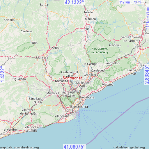
Sentmenat GPS coordinates[2]
41° 36' 31.032" North, 2° 8' 7.152" East
| Map corner | latitude | longitude |
|---|---|---|
| Upper-left | 42.1322°, | 1.4322° |
| Center: | 41.60862°, | 2.13532° |
| Lower-right: | 41.08075°, | 2.83845° |
| Map W x H: | 116.9×116.9 km | = 72.6×72.6mi |
| max Lat: | 43.74134° ⇑36.4% North |
| Sentmenat: | 41.60862° |
| min Lat: | ⇓63.6% South 27.64134° |
| min Long | Sentmenat | max Long |
| -18.00367° | 2.13532° | 4.2899° |
| W 94.1%⇐ | ⇒5.9% E |
Elevation
Elevation of Sentmenat is 213 m = 699 ft, and this is 385 m = 1263 ft below average elevation for this country.
| Max E: |
1682 m = 5518 ft | 80.4% |
| Avg. | 598 m = 1962 ft | |
| Sentmenat | 213 m = 699 ft | |
Min E: |
0 m = 0 ft | 19.6% |
See also: Spain elevation on elevation.city.
Geographical zone
Sentmenat is located in North temperate zone (between Tropic of Cancer and the Arctic Circle). Distance of this Northern Tropic circle is 2020.5 km =1255.5 mi to South.| Distance of | km | miles | from Sentmenat |
|---|---|---|---|
| North Pole | 5380.6 | 3343.3 | to North |
| Arctic Circle | 2774.7 | 1724.1 | to North |
| Tropic Cancer | 2020.5 | 1255.5 | to South |
| Equator | 4626.4 | 2874.7 | to South |


Nearby cities:
15 places around Sentmenat: (largest is in red/bold)
• Barberà del Vallès
10.3 km =6.4 mi,  184°
184°
• Caldes de Montbui
3.8 km =2.4 mi,  43°
43°
• Castellar del Vallès
4.4 km =2.7 mi,  281°
281°
• Gallifa
9.5 km =5.9 mi,  348°
348°
• Lliçà d'Amunt
8.2 km =5.1 mi,  83°
83°
• Lliçà de Vall
9 km =5.6 mi,  102°
102°
• Matadepera
9.1 km =5.7 mi,  263°
263°
• Mollet del Vallès
10 km =6.2 mi,  139°
139°
• Parets del Vallès
9 km =5.6 mi,  114°
114°
• Polinyà
6.6 km =4.1 mi,  169°
169°
• Sabadell
7.6 km =4.7 mi,  196°
196°
• Sant Feliu de Codines
10.5 km =6.5 mi,  14°
14°
• Sant Quirze del Vallès
9.4 km =5.8 mi,  207°
207°
• Santa Eulàlia de Ronçana
9.4 km =5.8 mi,  60°
60°
• Santa Perpètua de Mogoda
9.3 km =5.8 mi,  154°
154°
Sources, notices
• [Note1] Compared only with cities in Spain existing in our database
• [Src1] Map data: © OpenStreetMap contributors (CC-BY-SA)
• [Src2] Other city data from geonames.org with taken over terms of usage.
• [Src3] Geographical zone / Annual Mean Temperature by Robert A. Rohde @ Wikipedia
