Gallifa geodata
Gallifa (Catalonia) is a seat of a third-order administrative division; located in Spain in Europe/Madrid (GMT+2) time zone. With population of 218 people, there are 4933 cities with bigger population in this country. Compared to other cities in Spain, 65.9% of cities are located further ↓South; 93.9% of cities are located further ←West and 63.4% of cities have higher elevation than Gallifa. Note1


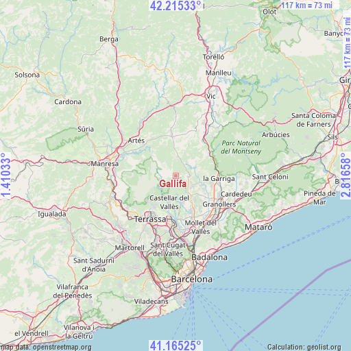
Gallifa GPS coordinates[2]
41° 41' 32.748" North, 2° 6' 48.456" East
| Map corner | latitude | longitude |
|---|---|---|
| Upper-left | 42.21533°, | 1.41033° |
| Center: | 41.69243°, | 2.11346° |
| Lower-right: | 41.16525°, | 2.81658° |
| Map W x H: | 116.8×116.8 km | = 72.6×72.6mi |
| max Lat: | 43.74134° ⇑34.1% North |
| Gallifa: | 41.69243° |
| min Lat: | ⇓65.9% South 27.64134° |
| min Long | Gallifa | max Long |
| -18.00367° | 2.11346° | 4.2899° |
| W 93.9%⇐ | ⇒6.1% E |
Elevation
Elevation of Gallifa is 482 m = 1581 ft, and this is 116 m = 381 ft below average elevation for this country.
| Max E: |
1682 m = 5518 ft | 63.4% |
| Avg. | 598 m = 1962 ft | |
| Gallifa | 482 m = 1581 ft | |
Min E: |
0 m = 0 ft | 36.6% |
See also: Spain elevation on elevation.city.
Geographical zone
Gallifa is located in North temperate zone (between Tropic of Cancer and the Arctic Circle). Distance of this Northern Tropic circle is 2029.8 km =1261.3 mi to South.| Distance of | km | miles | from Gallifa |
|---|---|---|---|
| North Pole | 5371.3 | 3337.6 | to North |
| Arctic Circle | 2765.4 | 1718.3 | to North |
| Tropic Cancer | 2029.8 | 1261.3 | to South |
| Equator | 4635.8 | 2880.6 | to South |


Nearby cities:
15 places around Gallifa: (largest is in red/bold)
• Bigues i Riells
10 km =6.2 mi,  95°
95°
• Caldes de Montbui
7.9 km =4.9 mi,  146°
146°
• Castellar del Vallès
8.8 km =5.5 mi,  196°
196°
• Castellcir
8.6 km =5.3 mi,  27°
27°
• Castellterçol
6.4 km =4 mi,  2°
2°
• Granera
5.9 km =3.7 mi,  310°
310°
• Matadepera
12.7 km =7.9 mi,  214°
214°
• Monistrol de Calders
11 km =6.8 mi, 313°
• Mura
11.4 km =7.1 mi,  273°
273°
• Sant Feliu de Codines
4.5 km =2.8 mi,  79°
79°
• Sant Martí de Centelles
11.2 km =7 mi,  43°
43°
• Sant Quirze Safaja
5.5 km =3.4 mi, 33°
• Santa Eulàlia de Ronçana
11 km =6.8 mi,  115°
115°
• Sentmenat
9.5 km =5.9 mi,  168°
168°
• Talamanca
12.3 km =7.6 mi,  293°
293°
Sources, notices
• [Note1] Compared only with cities in Spain existing in our database
• [Src1] Map data: © OpenStreetMap contributors (CC-BY-SA)
• [Src2] Other city data from geonames.org with taken over terms of usage.
• [Src3] Geographical zone / Annual Mean Temperature by Robert A. Rohde @ Wikipedia
