Polinyà geodata
Polinyà (Catalonia) is a seat of a third-order administrative division; located in Spain in Europe/Madrid (GMT+2) time zone. With population of 6,176 people, there are 1114 cities with bigger population in this country. Compared to other cities in Spain, 62.1% of cities are located further ↓South; 94.3% of cities are located further ←West and 83.5% of cities have higher elevation than Polinyà. Note1


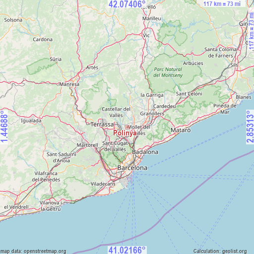
Polinyà GPS coordinates[2]
41° 33' 0" North, 2° 9' 0" East
| Map corner | latitude | longitude |
|---|---|---|
| Upper-left | 42.07406°, | 1.44688° |
| Center: | 41.55°, | 2.15° |
| Lower-right: | 41.02166°, | 2.85313° |
| Map W x H: | 117×117 km | = 72.7×72.7mi |
| max Lat: | 43.74134° ⇑37.9% North |
| Polinyà: | 41.55° |
| min Lat: | ⇓62.1% South 27.64134° |
| min Long | Polinyà | max Long |
| -18.00367° | 2.15° | 4.2899° |
| W 94.3%⇐ | ⇒5.7% E |
Elevation
Elevation of Polinyà is 162 m = 531 ft, and this is 436 m = 1430 ft below average elevation for this country.
| Max E: |
1682 m = 5518 ft | 83.5% |
| Avg. | 598 m = 1962 ft | |
| Polinyà | 162 m = 531 ft | |
Min E: |
0 m = 0 ft | 16.5% |
See also: Spain elevation on elevation.city.
Geographical zone
Polinyà is located in North temperate zone (between Tropic of Cancer and the Arctic Circle). Distance of this Northern Tropic circle is 2014 km =1251.4 mi to South.| Distance of | km | miles | from Polinyà |
|---|---|---|---|
| North Pole | 5387.1 | 3347.4 | to North |
| Arctic Circle | 2781.2 | 1728.2 | to North |
| Tropic Cancer | 2014 | 1251.4 | to South |
| Equator | 4619.9 | 2870.7 | to South |


Nearby cities:
15 places around Polinyà: (largest is in red/bold)
• Barberà del Vallès
4.3 km =2.7 mi,  209°
209°
• Caldes de Montbui
9.4 km =5.8 mi,  8°
8°
• Castellar del Vallès
9.3 km =5.8 mi,  323°
323°
• Cerdanyola del Vallès
6.6 km =4.1 mi,  186°
186°
• La Llagosta
5.3 km =3.3 mi,  137°
137°
• Lliçà de Vall
8.8 km =5.5 mi,  59°
59°
• Mollet del Vallès
5.4 km =3.4 mi,  101°
101°
• Montcada i Reixac
7.9 km =4.9 mi,  159°
159°
• Montmeló
7.6 km =4.7 mi,  89°
89°
• Parets del Vallès
7.4 km =4.6 mi,  68°
68°
• Ripollet
5.9 km =3.7 mi,  174°
174°
• Sabadell
3.5 km =2.2 mi,  257°
257°
• Sant Quirze del Vallès
5.8 km =3.6 mi,  251°
251°
• Santa Perpètua de Mogoda
3.3 km =2.1 mi,  123°
123°
• Sentmenat
6.6 km =4.1 mi,  349°
349°
Sources, notices
• [Note1] Compared only with cities in Spain existing in our database
• [Src1] Map data: © OpenStreetMap contributors (CC-BY-SA)
• [Src2] Other city data from geonames.org with taken over terms of usage.
• [Src3] Geographical zone / Annual Mean Temperature by Robert A. Rohde @ Wikipedia
