Vilademuls geodata
Vilademuls (Catalonia) is a seat of a third-order administrative division; located in Spain in Europe/Madrid (GMT+2) time zone. With population of 772 people, there are 3263 cities with bigger population in this country. Compared to other cities in Spain, 77.6% of cities are located further ↓South; 98% of cities are located further ←West and 86% of cities have higher elevation than Vilademuls. Note1


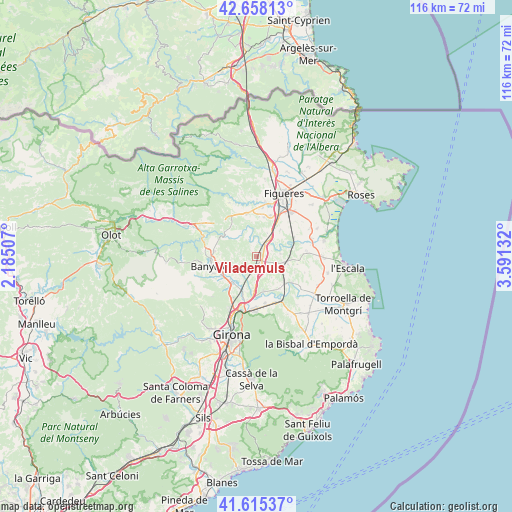
Vilademuls GPS coordinates[2]
42° 8' 20.04" North, 2° 53' 17.484" East
| Map corner | latitude | longitude |
|---|---|---|
| Upper-left | 42.65813°, | 2.18507° |
| Center: | 42.1389°, | 2.88819° |
| Lower-right: | 41.61537°, | 3.59132° |
| Map W x H: | 115.9×115.9 km | = 72×72mi |
| max Lat: | 43.74134° ⇑22.4% North |
| Vilademuls: | 42.1389° |
| min Lat: | ⇓77.6% South 27.64134° |
| min Long | Vilademuls | max Long |
| -18.00367° | 2.88819° | 4.2899° |
| W 98%⇐ | ⇒2% E |
Elevation
Elevation of Vilademuls is 123 m = 404 ft, and this is 475 m = 1558 ft below average elevation for this country.
| Max E: |
1682 m = 5518 ft | 86% |
| Avg. | 598 m = 1962 ft | |
| Vilademuls | 123 m = 404 ft | |
Min E: |
0 m = 0 ft | 14% |
See also: Spain elevation on elevation.city.
Geographical zone
Vilademuls is located in North temperate zone (between Tropic of Cancer and the Arctic Circle). Distance of this Northern Tropic circle is 2079.5 km =1292.1 mi to South.| Distance of | km | miles | from Vilademuls |
|---|---|---|---|
| North Pole | 5321.7 | 3306.8 | to North |
| Arctic Circle | 2715.8 | 1687.5 | to North |
| Tropic Cancer | 2079.5 | 1292.1 | to South |
| Equator | 4685.4 | 2911.4 | to South |


Nearby cities:
15 places around Vilademuls: (largest is in red/bold)
• Bàscara
3 km =1.9 mi,  37°
37°
• Cervià de Ter
8.2 km =5.1 mi,  168°
168°
• Cornellà del Terri
8.5 km =5.3 mi,  223°
223°
• Crespià
8.8 km =5.5 mi,  304°
304°
• Esponellà
7.9 km =4.9 mi,  293°
293°
• Fontcoberta
7.3 km =4.5 mi,  265°
265°
• Garrigàs
8.2 km =5.1 mi, 41°
• Navata
9.7 km =6 mi,  346°
346°
• Ordis
9 km =5.6 mi,  9°
9°
• Pontós
5.8 km =3.6 mi,  24°
24°
• Sant Jordi Desvalls
9.5 km =5.9 mi,  147°
147°
• Sant Miquel de Fluvià
9.4 km =5.8 mi,  66°
66°
• Sant Mori
8.6 km =5.3 mi,  77°
77°
• Saus
7.4 km =4.6 mi,  95°
95°
• Viladasens
7.2 km =4.5 mi, 148°
Sources, notices
• [Note1] Compared only with cities in Spain existing in our database
• [Src1] Map data: © OpenStreetMap contributors (CC-BY-SA)
• [Src2] Other city data from geonames.org with taken over terms of usage.
• [Src3] Geographical zone / Annual Mean Temperature by Robert A. Rohde @ Wikipedia
