Sants geodata
Sants (Catalonia) is a section of populated place; located in Spain in Europe/Madrid (GMT+2) time zone. With population of 41,313 people, there are 211 cities with bigger population in this country. Compared to other cities in Spain, 56.8% of cities are located further ↓South; 94.1% of cities are located further ←West and 91.9% of cities have higher elevation than Sants. Note1
Administrative division(s):
- Level 1: Catalonia
- Level 2: Província de Barcelona
- Level 3: Barcelona
- Level 4: Sants-Montjuïc


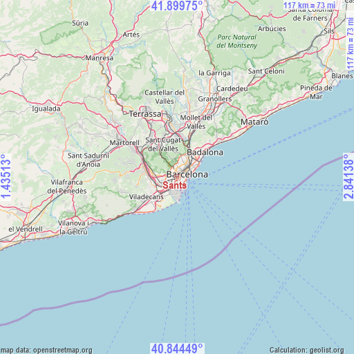
Sants GPS coordinates[2]
41° 22' 27.336" North, 2° 8' 17.736" East
| Map corner | latitude | longitude |
|---|---|---|
| Upper-left | 41.89975°, | 1.43513° |
| Center: | 41.37426°, | 2.13826° |
| Lower-right: | 40.84449°, | 2.84138° |
| Map W x H: | 117.3×117.3 km | = 72.9×72.9mi |
| max Lat: | 43.74134° ⇑43.2% North |
| Sants: | 41.37426° |
| min Lat: | ⇓56.8% South 27.64134° |
| min Long | Sants | max Long |
| -18.00367° | 2.13826° | 4.2899° |
| W 94.1%⇐ | ⇒5.9% E |
Elevation
Elevation of Sants is 45 m = 148 ft, and this is 553 m = 1814 ft below average elevation for this country.
| Max E: |
1682 m = 5518 ft | 91.9% |
| Avg. | 598 m = 1962 ft | |
| Sants | 45 m = 148 ft | |
Min E: |
0 m = 0 ft | 8.1% |
See also: Sants elevation on elevation.city.
Geographical zone
Sants is located in North temperate zone (between Tropic of Cancer and the Arctic Circle). Distance of this Northern Tropic circle is 1994.5 km =1239.3 mi to South.| Distance of | km | miles | from Sants |
|---|---|---|---|
| North Pole | 5406.7 | 3359.6 | to North |
| Arctic Circle | 2800.8 | 1740.3 | to North |
| Tropic Cancer | 1994.5 | 1239.3 | to South |
| Equator | 4600.4 | 2858.6 | to South |


Nearby cities:
15 places around Sants: (largest is in red/bold)
• Barcelona
2.4 km =1.5 mi,  46°
46°
• Barri de les Corts
1.4 km =0.9 mi,  348°
348°
• Hostafrancs
0.5 km =0.3 mi, 53°
• La Bordeta
0.5 km =0.3 mi,  94°
94°
• Les Corts
1.6 km =1 mi,  334°
334°
• Poble Sec
2.1 km =1.3 mi, 89°
• Sant Antoni
1.8 km =1.1 mi,  74°
74°
• Sant Gervasi - Galvany
2.6 km =1.6 mi,  8°
8°
• Sants - Badal
0.9 km =0.6 mi,  273°
273°
• Sants-Montjuïc
1.4 km =0.9 mi,  97°
97°
• l'Antiga Esquerra de l'Eixample
2.2 km =1.4 mi,  39°
39°
• la Font de la Guatlla
0.7 km =0.4 mi,  132°
132°
• la Marina de Port
1.6 km =1 mi,  175°
175°
• la Maternitat i Sant Ramon
1.9 km =1.2 mi,  294°
294°
• la Nova Esquerra de l'Eixample
1.3 km =0.8 mi, 42°
Sources, notices
• [Note1] Compared only with cities in Spain existing in our database
• [Src1] Map data: © OpenStreetMap contributors (CC-BY-SA)
• [Src2] Other city data from geonames.org with taken over terms of usage.
• [Src3] Geographical zone / Annual Mean Temperature by Robert A. Rohde @ Wikipedia
