la Font de la Guatlla geodata
la Font de la Guatlla (Catalonia) is a section of populated place; located in Spain in Europe/Madrid (GMT+2) time zone. With population of 10,481 people, there are 827 cities with bigger population in this country. Compared to other cities in Spain, 56.7% of cities are located further ↓South; 94.3% of cities are located further ←West and 91.5% of cities have higher elevation than la Font de la Guatlla. Note1
Administrative division(s):
- Level 1: Catalonia
- Level 2: Província de Barcelona
- Level 3: Barcelona
- Level 4: Sants-Montjuïc
Current local time in la Font de la Guatlla:
10:47 PM, ThursdayDifference from your time zone: hours


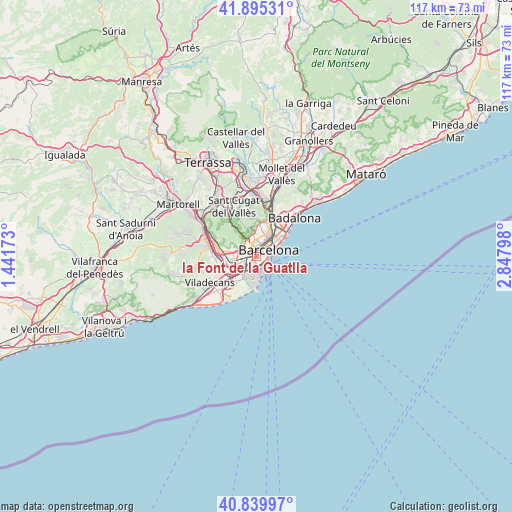
la Font de la Guatlla GPS coordinates[2]
41° 22' 11.208" North, 2° 8' 41.496" East
| Map corner | latitude | longitude |
|---|---|---|
| Upper-left | 41.89531°, | 1.44173° |
| Center: | 41.36978°, | 2.14486° |
| Lower-right: | 40.83997°, | 2.84798° |
| Map W x H: | 117.3×117.3 km | = 72.9×72.9mi |
| max Lat: | 43.74134° ⇑43.3% North |
| la Font de la Guatlla: | 41.36978° |
| min Lat: | ⇓56.7% South 27.64134° |
| min Long | la Font de la G | max Long |
| -18.00367° | 2.14486° | 4.2899° |
| W 94.3%⇐ | ⇒5.7% E |
Elevation
Elevation of la Font de la Guatlla is 48 m = 157 ft, and this is 550 m = 1804 ft below average elevation for this country.
| Max E: |
1682 m = 5518 ft | 91.5% |
| Avg. | 598 m = 1962 ft | |
| la Font de la Guatlla | 48 m = 157 ft | |
Min E: |
0 m = 0 ft | 8.5% |
See also: Spain elevation on elevation.city.
Geographical zone
la Font de la Guatlla is located in North temperate zone (between Tropic of Cancer and the Arctic Circle). Distance of this Northern Tropic circle is 1994 km =1239 mi to South.| Distance of | km | miles | from la Font de la Guatlla |
|---|---|---|---|
| North Pole | 5407.2 | 3359.9 | to North |
| Arctic Circle | 2801.3 | 1740.6 | to North |
| Tropic Cancer | 1994 | 1239 | to South |
| Equator | 4599.9 | 2858.2 | to South |


Nearby cities:
15 places around la Font de la Guatlla: (largest is in red/bold)
• Barcelona
2.4 km =1.5 mi,  29°
29°
• Barri de les Corts
2.1 km =1.3 mi,  336°
336°
• Eixample
2.6 km =1.6 mi, 33°
• Hostafrancs
0.8 km =0.5 mi,  349°
349°
• La Bordeta
0.5 km =0.3 mi, 348°
• Les Corts
2.3 km =1.4 mi,  327°
327°
• Poble Sec
1.6 km =1 mi,  71°
71°
• Sant Antoni
1.6 km =1 mi,  51°
51°
• Sants
0.7 km =0.4 mi,  312°
312°
• Sants - Badal
1.5 km =0.9 mi,  291°
291°
• Sants-Montjuïc
0.9 km =0.6 mi, 68°
• el Raval
2.3 km =1.4 mi,  59°
59°
• l'Antiga Esquerra de l'Eixample
2.3 km =1.4 mi,  21°
21°
• la Marina de Port
1.2 km =0.7 mi,  200°
200°
• la Nova Esquerra de l'Eixample
1.5 km =0.9 mi,  13°
13°
Sources, notices
• [Note1] Compared only with cities in Spain existing in our database
• [Src1] Map data: © OpenStreetMap contributors (CC-BY-SA)
• [Src2] Other city data from geonames.org with taken over terms of usage.
• [Src3] Geographical zone / Annual Mean Temperature by Robert A. Rohde @ Wikipedia
