Santovenia geodata
Santovenia (Castille and León) is a seat of a third-order administrative division; located in Spain in Europe/Madrid (GMT+2) time zone. With population of 354 people, there are 4302 cities with bigger population in this country. Compared to other cities in Spain, 70.4% of cities are located further ↓South; 81.9% of cities are located further →East and 55.7% of cities have lower elevation than Santovenia. Note1
Administrative division(s):
- Level 1: Castille and León
- Level 2: Provincia de Zamora
- Level 3: Santovenia


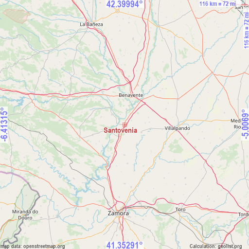
Santovenia GPS coordinates[2]
41° 52' 42.852" North, 5° 42' 36.108" West
| Map corner | latitude | longitude |
|---|---|---|
| Upper-left | 42.39994°, | -6.41315° |
| Center: | 41.87857°, | -5.71003° |
| Lower-right: | 41.35291°, | -5.0069° |
| Map W x H: | 116.4×116.4 km | = 72.3×72.3mi |
| max Lat: | 43.74134° ⇑29.6% North |
| Santovenia: | 41.87857° |
| min Lat: | ⇓70.4% South 27.64134° |
| min Long | Santovenia | max Long |
| -18.00367° | -5.71003° | 4.2899° |
| W 18.1%⇐ | ⇒81.9% E |
Elevation
Elevation of Santovenia is 714 m = 2343 ft, and this is 116 m = 381 ft above average elevation for this country.
| Max E: |
1682 m = 5518 ft | 44.3% |
| Santovenia | 714 m 2343 ft | |
| Avg. | 598 m = 1962 ft | |
Min E: |
0 m = 0 ft | 55.7% |
See also: Spain elevation on elevation.city.
Geographical zone
Santovenia is located in North temperate zone (between Tropic of Cancer and the Arctic Circle). Distance of this Northern Tropic circle is 2050.5 km =1274.1 mi to South.| Distance of | km | miles | from Santovenia |
|---|---|---|---|
| North Pole | 5350.6 | 3324.7 | to North |
| Arctic Circle | 2744.7 | 1705.5 | to North |
| Tropic Cancer | 2050.5 | 1274.1 | to South |
| Equator | 4656.5 | 2893.4 | to South |


Nearby cities:
15 places around Santovenia: (largest is in red/bold)
• Arcos de la Polvorosa
7.3 km =4.5 mi,  8°
8°
• Barcial del Barco
7.3 km =4.5 mi,  32°
32°
• Bretocino
3.8 km =2.4 mi,  279°
279°
• Bretó
2.4 km =1.5 mi,  271°
271°
• Burganes de Valverde
7.6 km =4.7 mi,  308°
308°
• Friera de Valverde
11.5 km =7.1 mi,  288°
288°
• Granja de Moreruela
8 km =5 mi,  197°
197°
• Milles de la Polvorosa
5.3 km =3.3 mi,  339°
339°
• San Agustín del Pozo
9.7 km =6 mi,  85°
85°
• Santa Colomba de las Monjas
9.1 km =5.7 mi, 13°
• Vidayanes
11.8 km =7.3 mi,  72°
72°
• Villafáfila
8.6 km =5.3 mi,  114°
114°
• Villanueva de Azoague
11.5 km =7.1 mi,  19°
19°
• Villarrín de Campos
11 km =6.8 mi,  147°
147°
• Villaveza del Agua
5.2 km =3.2 mi, 29°
Sources, notices
• [Note1] Compared only with cities in Spain existing in our database
• [Src1] Map data: © OpenStreetMap contributors (CC-BY-SA)
• [Src2] Other city data from geonames.org with taken over terms of usage.
• [Src3] Geographical zone / Annual Mean Temperature by Robert A. Rohde @ Wikipedia
