Villaveza del Agua geodata
Villaveza del Agua (Castille and León) is a seat of a third-order administrative division; located in Spain in Europe/Madrid (GMT+2) time zone. With population of 262 people, there are 4676 cities with bigger population in this country. Compared to other cities in Spain, 71.3% of cities are located further ↓South; 81.4% of cities are located further →East and 54.8% of cities have lower elevation than Villaveza del Agua. Note1
Administrative division(s):
- Level 1: Castille and León
- Level 2: Provincia de Zamora
- Level 3: Villaveza del Agua


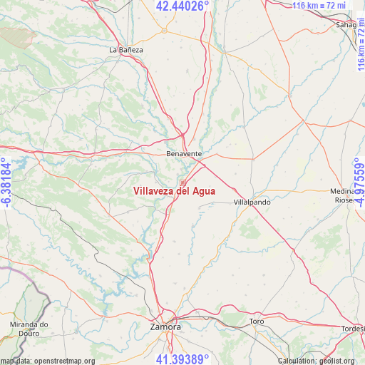
Villaveza del Agua GPS coordinates[2]
41° 55' 9.192" North, 5° 40' 43.356" West
| Map corner | latitude | longitude |
|---|---|---|
| Upper-left | 42.44026°, | -6.38184° |
| Center: | 41.91922°, | -5.67871° |
| Lower-right: | 41.39389°, | -4.97559° |
| Map W x H: | 116.3×116.3 km | = 72.3×72.3mi |
| max Lat: | 43.74134° ⇑28.7% North |
| Villaveza del Agua: | 41.91922° |
| min Lat: | ⇓71.3% South 27.64134° |
| min Long | Villaveza del A | max Long |
| -18.00367° | -5.67871° | 4.2899° |
| W 18.6%⇐ | ⇒81.4% E |
Elevation
Elevation of Villaveza del Agua is 708 m = 2323 ft, and this is 110 m = 361 ft above average elevation for this country.
| Max E: |
1682 m = 5518 ft | 45.2% |
| Villaveza del Agua | 708 m 2323 ft | |
| Avg. | 598 m = 1962 ft | |
Min E: |
0 m = 0 ft | 54.8% |
See also: Spain elevation on elevation.city.
Geographical zone
Villaveza del Agua is located in North temperate zone (between Tropic of Cancer and the Arctic Circle). Distance of this Northern Tropic circle is 2055.1 km =1277 mi to South.| Distance of | km | miles | from Villaveza del Agua |
|---|---|---|---|
| North Pole | 5346.1 | 3321.9 | to North |
| Arctic Circle | 2740.2 | 1702.7 | to North |
| Tropic Cancer | 2055.1 | 1277 | to South |
| Equator | 4661 | 2896.2 | to South |


Nearby cities:
15 places around Villaveza del Agua: (largest is in red/bold)
• Arcos de la Polvorosa
3.1 km =1.9 mi,  330°
330°
• Barcial del Barco
2.1 km =1.3 mi,  39°
39°
• Benavente
9.3 km =5.8 mi,  0°
0°
• Bretocino
7.4 km =4.6 mi,  238°
238°
• Bretó
6.7 km =4.2 mi,  228°
228°
• Burganes de Valverde
8.6 km =5.3 mi,  271°
271°
• Milles de la Polvorosa
4.5 km =2.8 mi,  275°
275°
• Revellinos
9.7 km =6 mi,  109°
109°
• San Agustín del Pozo
8 km =5 mi,  117°
117°
• Santa Colomba de las Monjas
4.4 km =2.7 mi,  354°
354°
• Santa Cristina de la Polvorosa
9.4 km =5.8 mi,  342°
342°
• Santovenia
5.2 km =3.2 mi,  209°
209°
• Vidayanes
8.7 km =5.4 mi,  96°
96°
• Villafáfila
9.6 km =6 mi,  146°
146°
• Villanueva de Azoague
6.4 km =4 mi,  10°
10°
Sources, notices
• [Note1] Compared only with cities in Spain existing in our database
• [Src1] Map data: © OpenStreetMap contributors (CC-BY-SA)
• [Src2] Other city data from geonames.org with taken over terms of usage.
• [Src3] Geographical zone / Annual Mean Temperature by Robert A. Rohde @ Wikipedia
