Villafáfila geodata
Villafáfila (Castille and León) is a seat of a third-order administrative division; located in Spain in Europe/Madrid (GMT+2) time zone. With population of 629 people, there are 3548 cities with bigger population in this country. Compared to other cities in Spain, 69.7% of cities are located further ↓South; 80.3% of cities are located further →East and 53% of cities have lower elevation than Villafáfila. Note1
Administrative division(s):
- Level 1: Castille and León
- Level 2: Provincia de Zamora
- Level 3: Villafáfila


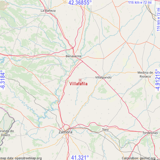
Villafáfila GPS coordinates[2]
41° 50' 48.912" North, 5° 36' 54.972" West
| Map corner | latitude | longitude |
|---|---|---|
| Upper-left | 42.36855°, | -6.3184° |
| Center: | 41.84692°, | -5.61527° |
| Lower-right: | 41.321°, | -4.91215° |
| Map W x H: | 116.5×116.5 km | = 72.4×72.4mi |
| max Lat: | 43.74134° ⇑30.3% North |
| Villafáfila: | 41.84692° |
| min Lat: | ⇓69.7% South 27.64134° |
| min Long | Villafáfila | max Long |
| -18.00367° | -5.61527° | 4.2899° |
| W 19.7%⇐ | ⇒80.3% E |
Elevation
Elevation of Villafáfila is 691 m = 2267 ft, and this is 93 m = 305 ft above average elevation for this country.
| Max E: |
1682 m = 5518 ft | 47% |
| Villafáfila | 691 m 2267 ft | |
| Avg. | 598 m = 1962 ft | |
Min E: |
0 m = 0 ft | 53% |
See also: Spain elevation on elevation.city.
Geographical zone
Villafáfila is located in North temperate zone (between Tropic of Cancer and the Arctic Circle). Distance of this Northern Tropic circle is 2047 km =1271.9 mi to South.| Distance of | km | miles | from Villafáfila |
|---|---|---|---|
| North Pole | 5354.1 | 3326.9 | to North |
| Arctic Circle | 2748.2 | 1707.7 | to North |
| Tropic Cancer | 2047 | 1271.9 | to South |
| Equator | 4652.9 | 2891.2 | to South |


Nearby cities:
15 places around Villafáfila: (largest is in red/bold)
• Barcial del Barco
10.4 km =6.5 mi,  337°
337°
• Bretocino
12.3 km =7.6 mi,  289°
289°
• Bretó
10.9 km =6.8 mi, 289°
• Cerecinos de Campos
12.2 km =7.6 mi,  61°
61°
• Granja de Moreruela
11 km =6.8 mi,  248°
248°
• Revellinos
6.1 km =3.8 mi,  38°
38°
• San Agustín del Pozo
4.7 km =2.9 mi,  22°
22°
• San Esteban del Molar
11.3 km =7 mi,  27°
27°
• San Martín de Valderaduey
12.4 km =7.7 mi,  107°
107°
• Santovenia
8.6 km =5.3 mi, 294°
• Tapioles
9.9 km =6.2 mi,  83°
83°
• Vidayanes
7.8 km =4.8 mi, 25°
• Villalba de la Lampreana
11.7 km =7.3 mi,  190°
190°
• Villarrín de Campos
6.1 km =3.8 mi,  198°
198°
• Villaveza del Agua
9.6 km =6 mi,  326°
326°
Sources, notices
• [Note1] Compared only with cities in Spain existing in our database
• [Src1] Map data: © OpenStreetMap contributors (CC-BY-SA)
• [Src2] Other city data from geonames.org with taken over terms of usage.
• [Src3] Geographical zone / Annual Mean Temperature by Robert A. Rohde @ Wikipedia
