Santiuste geodata
Santiuste (Castille-La Mancha) is a seat of a third-order administrative division; located in Spain in Europe/Madrid (GMT+2) time zone. With population of 23 people, there are 6702 cities with bigger population in this country. Compared to other cities in Spain, 50.5% of cities are located further ↓South; 57.3% of cities are located further ←West and 82.2% of cities have lower elevation than Santiuste. Note1
Administrative division(s):
- Level 1: Castille-La Mancha
- Level 2: Provincia de Guadalajara
- Level 3: Santiuste


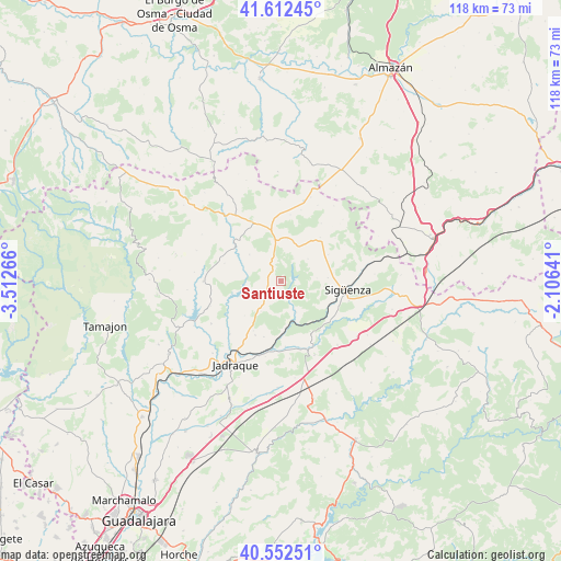
Santiuste GPS coordinates[2]
41° 5' 4.632" North, 2° 48' 34.308" West
| Map corner | latitude | longitude |
|---|---|---|
| Upper-left | 41.61245°, | -3.51266° |
| Center: | 41.08462°, | -2.80953° |
| Lower-right: | 40.55251°, | -2.10641° |
| Map W x H: | 117.9×117.9 km | = 73.3×73.3mi |
| max Lat: | 43.74134° ⇑49.5% North |
| Santiuste: | 41.08462° |
| min Lat: | ⇓50.5% South 27.64134° |
| min Long | Santiuste | max Long |
| -18.00367° | -2.80953° | 4.2899° |
| W 57.3%⇐ | ⇒42.7% E |
Elevation
Elevation of Santiuste is 919 m = 3015 ft, and this is 321 m = 1053 ft above average elevation for this country.
| Max E: |
1682 m = 5518 ft | 17.8% |
| Santiuste | 919 m 3015 ft | |
| Avg. | 598 m = 1962 ft | |
Min E: |
0 m = 0 ft | 82.2% |
See also: Spain elevation on elevation.city.
Geographical zone
Santiuste is located in North temperate zone (between Tropic of Cancer and the Arctic Circle). Distance of this Northern Tropic circle is 1962.3 km =1219.3 mi to South.| Distance of | km | miles | from Santiuste |
|---|---|---|---|
| North Pole | 5438.9 | 3379.6 | to North |
| Arctic Circle | 2833 | 1760.3 | to North |
| Tropic Cancer | 1962.3 | 1219.3 | to South |
| Equator | 4568.2 | 2838.5 | to South |


Nearby cities:
15 places around Santiuste: (largest is in red/bold)
• Alcolea de las Peñas
14 km =8.7 mi,  8°
8°
• Atienza
13.5 km =8.4 mi,  337°
337°
• Baides
9.1 km =5.7 mi,  162°
162°
• Cendejas de la Torre
12.2 km =7.6 mi,  196°
196°
• Cincovillas
13.4 km =8.3 mi,  356°
356°
• Huérmeces del Cerro
3.6 km =2.2 mi, 163°
• Negredo
7.6 km =4.7 mi,  212°
212°
• Pinilla de Jadraque
13.3 km =8.3 mi,  237°
237°
• Pálmaces de Jadraque
9 km =5.6 mi,  249°
249°
• Rebollosa de Jadraque
2.8 km =1.7 mi,  283°
283°
• Robledo de Corpes
12.4 km =7.7 mi,  287°
287°
• Sigüenza
14.1 km =8.8 mi,  97°
97°
• Torremocha de Jadraque
10.5 km =6.5 mi,  225°
225°
• Viana de Jadraque
7.3 km =4.5 mi,  152°
152°
• Villaseca de Henares
13.8 km =8.6 mi,  175°
175°
Sources, notices
• [Note1] Compared only with cities in Spain existing in our database
• [Src1] Map data: © OpenStreetMap contributors (CC-BY-SA)
• [Src2] Other city data from geonames.org with taken over terms of usage.
• [Src3] Geographical zone / Annual Mean Temperature by Robert A. Rohde @ Wikipedia
