Negredo geodata
Negredo (Castille-La Mancha) is a seat of a third-order administrative division; located in Spain in Europe/Madrid (GMT+2) time zone. With population of 21 people, there are 6716 cities with bigger population in this country. Compared to other cities in Spain, 51% of cities are located further ↑North; 56.6% of cities are located further ←West and 87.4% of cities have lower elevation than Negredo. Note1
Administrative division(s):
- Level 1: Castille-La Mancha
- Level 2: Provincia de Guadalajara
- Level 3: Negredo


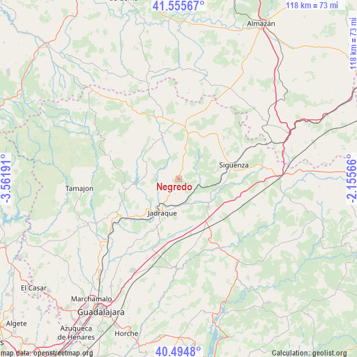
Negredo GPS coordinates[2]
41° 1' 38.532" North, 2° 51' 31.608" West
| Map corner | latitude | longitude |
|---|---|---|
| Upper-left | 41.55567°, | -3.56191° |
| Center: | 41.02737°, | -2.85878° |
| Lower-right: | 40.4948°, | -2.15566° |
| Map W x H: | 118×118 km | = 73.3×73.3mi |
| max Lat: | 43.74134° ⇑51% North |
| Negredo: | 41.02737° |
| min Lat: | ⇓49% South 27.64134° |
| min Long | Negredo | max Long |
| -18.00367° | -2.85878° | 4.2899° |
| W 56.6%⇐ | ⇒43.4% E |
Elevation
Elevation of Negredo is 988 m = 3241 ft, and this is 390 m = 1280 ft above average elevation for this country.
| Max E: |
1682 m = 5518 ft | 12.6% |
| Negredo | 988 m 3241 ft | |
| Avg. | 598 m = 1962 ft | |
Min E: |
0 m = 0 ft | 87.4% |
See also: Spain elevation on elevation.city.
Geographical zone
Negredo is located in North temperate zone (between Tropic of Cancer and the Arctic Circle). Distance of this Northern Tropic circle is 1955.9 km =1215.3 mi to South.| Distance of | km | miles | from Negredo |
|---|---|---|---|
| North Pole | 5445.2 | 3383.5 | to North |
| Arctic Circle | 2839.4 | 1764.3 | to North |
| Tropic Cancer | 1955.9 | 1215.3 | to South |
| Equator | 4561.8 | 2834.6 | to South |


Nearby cities:
15 places around Negredo: (largest is in red/bold)
• Baides
7.3 km =4.5 mi,  108°
108°
• Bujalaro
10.3 km =6.4 mi,  191°
191°
• Cendejas de la Torre
5.4 km =3.4 mi,  172°
172°
• Congostrina
10.7 km =6.6 mi,  275°
275°
• Huérmeces del Cerro
5.9 km =3.7 mi,  60°
60°
• Jirueque
7.9 km =4.9 mi,  207°
207°
• Matillas
9.5 km =5.9 mi, 168°
• Medranda
8.2 km =5.1 mi,  233°
233°
• Pinilla de Jadraque
7.1 km =4.4 mi,  263°
263°
• Pálmaces de Jadraque
5.4 km =3.4 mi,  306°
306°
• Rebollosa de Jadraque
7.1 km =4.4 mi,  11°
11°
• Santiuste
7.6 km =4.7 mi,  32°
32°
• Torremocha de Jadraque
3.5 km =2.2 mi,  254°
254°
• Viana de Jadraque
7.5 km =4.7 mi,  91°
91°
• Villaseca de Henares
9 km =5.6 mi,  145°
145°
Sources, notices
• [Note1] Compared only with cities in Spain existing in our database
• [Src1] Map data: © OpenStreetMap contributors (CC-BY-SA)
• [Src2] Other city data from geonames.org with taken over terms of usage.
• [Src3] Geographical zone / Annual Mean Temperature by Robert A. Rohde @ Wikipedia
