Santibáñez de Valcorba geodata
Santibáñez de Valcorba (Castille and León) is a seat of a third-order administrative division; located in Spain in Europe/Madrid (GMT+2) time zone. With population of 190 people, there are 5108 cities with bigger population in this country. Compared to other cities in Spain, 62.6% of cities are located further ↓South; 65.5% of cities are located further →East and 60.9% of cities have lower elevation than Santibáñez de Valcorba. Note1
Administrative division(s):
- Level 1: Castille and León
- Level 2: Provincia de Valladolid
- Level 3: Santibáñez de Valcorba
Current local time in Santibáñez de Valcorba:
10:40 PM, ThursdayDifference from your time zone: hours


Santibáñez de Valcorba GPS coordinates[2]
41° 34' 11.388" North, 4° 26' 57.768" West
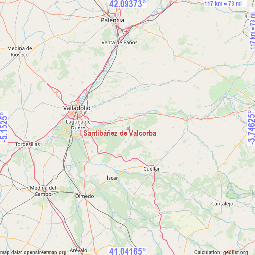
| Map corner | latitude | longitude |
|---|---|---|
| Upper-left | 42.09373°, | -5.1525° |
| Center: | 41.56983°, | -4.44938° |
| Lower-right: | 41.04165°, | -3.74625° |
| Map W x H: | 117×117 km | = 72.7×72.7mi |
| max Lat: | 43.74134° ⇑37.4% North |
| Santibáñez de Valcorba: | 41.56983° |
| min Lat: | ⇓62.6% South 27.64134° |
| min Long | Santibáñez de | max Long |
| -18.00367° | -4.44938° | 4.2899° |
| W 34.5%⇐ | ⇒65.5% E |
Elevation
Elevation of Santibáñez de Valcorba is 750 m = 2461 ft, and this is 152 m = 499 ft above average elevation for this country.
| Max E: |
1682 m = 5518 ft | 39.1% |
| Santibáñez de Valcorba | 750 m 2461 ft | |
| Avg. | 598 m = 1962 ft | |
Min E: |
0 m = 0 ft | 60.9% |
See also: Spain elevation on elevation.city.
Geographical zone
Santibáñez de Valcorba is located in North temperate zone (between Tropic of Cancer and the Arctic Circle). Distance of this Northern Tropic circle is 2016.2 km =1252.8 mi to South.| Distance of | km | miles | from Santibáñez de Valcorba |
|---|---|---|---|
| North Pole | 5384.9 | 3346 | to North |
| Arctic Circle | 2779 | 1726.8 | to North |
| Tropic Cancer | 2016.2 | 1252.8 | to South |
| Equator | 4622.1 | 2872 | to South |


Nearby cities:
15 places around Santibáñez de Valcorba: (largest is in red/bold)
• Camporredondo
11.7 km =7.3 mi,  203°
203°
• Cogeces del Monte
12.8 km =8 mi,  121°
121°
• La Parrilla
7.9 km =4.9 mi,  242°
242°
• Montemayor de Pililla
6.8 km =4.2 mi,  185°
185°
• Olivares de Duero
10.3 km =6.4 mi,  42°
42°
• Olmos de Esgueva
14.5 km =9 mi,  335°
335°
• Quintanilla de Onésimo
9.4 km =5.8 mi,  49°
49°
• San Miguel del Arroyo
14.1 km =8.8 mi,  183°
183°
• Sardón de Duero
4.5 km =2.8 mi,  16°
16°
• Torrescárcela
14.4 km =8.9 mi,  131°
131°
• Traspinedo
2.3 km =1.4 mi,  284°
284°
• Tudela de Duero
11.1 km =6.9 mi, 278°
• Villabáñez
9.1 km =5.7 mi,  318°
318°
• Villavaquerín
10.5 km =6.5 mi,  353°
353°
• Viloria
14.8 km =9.2 mi,  158°
158°
Sources, notices
• [Note1] Compared only with cities in Spain existing in our database
• [Src1] Map data: © OpenStreetMap contributors (CC-BY-SA)
• [Src2] Other city data from geonames.org with taken over terms of usage.
• [Src3] Geographical zone / Annual Mean Temperature by Robert A. Rohde @ Wikipedia
