La Parrilla geodata
La Parrilla (Castille and León) is a populated place; located in Spain in Europe/Madrid (GMT+2) time zone. With population of 623 people, there are 3561 cities with bigger population in this country. Compared to other cities in Spain, 61.7% of cities are located further ↓South; 66.7% of cities are located further →East and 76% of cities have lower elevation than La Parrilla. Note1
Administrative division(s):
- Level 1: Castille and León
- Level 2: Provincia de Valladolid
- Level 3: Parrilla, La


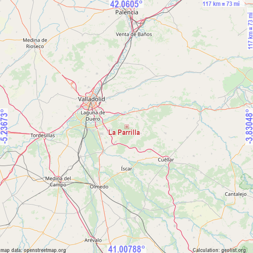
La Parrilla GPS coordinates[2]
41° 32' 10.788" North, 4° 32' 0.96" West
| Map corner | latitude | longitude |
|---|---|---|
| Upper-left | 42.0605°, | -5.23673° |
| Center: | 41.53633°, | -4.5336° |
| Lower-right: | 41.00788°, | -3.83048° |
| Map W x H: | 117×117 km | = 72.7×72.7mi |
| max Lat: | 43.74134° ⇑38.3% North |
| La Parrilla: | 41.53633° |
| min Lat: | ⇓61.7% South 27.64134° |
| min Long | La Parrilla | max Long |
| -18.00367° | -4.5336° | 4.2899° |
| W 33.3%⇐ | ⇒66.7% E |
Elevation
Elevation of La Parrilla is 860 m = 2822 ft, and this is 262 m = 860 ft above average elevation for this country.
| Max E: |
1682 m = 5518 ft | 24% |
| La Parrilla | 860 m 2822 ft | |
| Avg. | 598 m = 1962 ft | |
Min E: |
0 m = 0 ft | 76% |
See also: Spain elevation on elevation.city.
Geographical zone
La Parrilla is located in North temperate zone (between Tropic of Cancer and the Arctic Circle). Distance of this Northern Tropic circle is 2012.5 km =1250.5 mi to South.| Distance of | km | miles | from La Parrilla |
|---|---|---|---|
| North Pole | 5388.7 | 3348.4 | to North |
| Arctic Circle | 2782.8 | 1729.2 | to North |
| Tropic Cancer | 2012.5 | 1250.5 | to South |
| Equator | 4618.4 | 2869.7 | to South |


Nearby cities:
15 places around La Parrilla: (largest is in red/bold)
• Aldea de San Miguel
10.8 km =6.7 mi,  219°
219°
• Aldeamayor de San Martín
9.2 km =5.7 mi,  253°
253°
• Boecillo
13.8 km =8.6 mi,  272°
272°
• Camporredondo
7.4 km =4.6 mi,  161°
161°
• La Pedraja de Portillo
11.9 km =7.4 mi,  232°
232°
• Megeces
14.4 km =8.9 mi,  189°
189°
• Montemayor de Pililla
7 km =4.3 mi,  115°
115°
• Portillo
7.9 km =4.9 mi, 216°
• San Miguel del Arroyo
12 km =7.5 mi,  149°
149°
• Santibáñez de Valcorba
7.9 km =4.9 mi,  62°
62°
• Sardón de Duero
11.5 km =7.1 mi,  45°
45°
• Traspinedo
6.5 km =4 mi, 48°
• Tudela de Duero
6.6 km =4.1 mi,  323°
323°
• Villabáñez
10.6 km =6.6 mi,  5°
5°
• Villavaquerín
15.3 km =9.5 mi,  22°
22°
Sources, notices
• [Note1] Compared only with cities in Spain existing in our database
• [Src1] Map data: © OpenStreetMap contributors (CC-BY-SA)
• [Src2] Other city data from geonames.org with taken over terms of usage.
• [Src3] Geographical zone / Annual Mean Temperature by Robert A. Rohde @ Wikipedia
