Torrescárcela geodata
Torrescárcela (Castille and León) is a seat of a third-order administrative division; located in Spain in Europe/Madrid (GMT+2) time zone. With population of 166 people, there are 5297 cities with bigger population in this country. Compared to other cities in Spain, 60.5% of cities are located further ↓South; 64.1% of cities are located further →East and 79.2% of cities have lower elevation than Torrescárcela. Note1
Administrative division(s):
- Level 1: Castille and León
- Level 2: Provincia de Valladolid
- Level 3: Torrescárcela


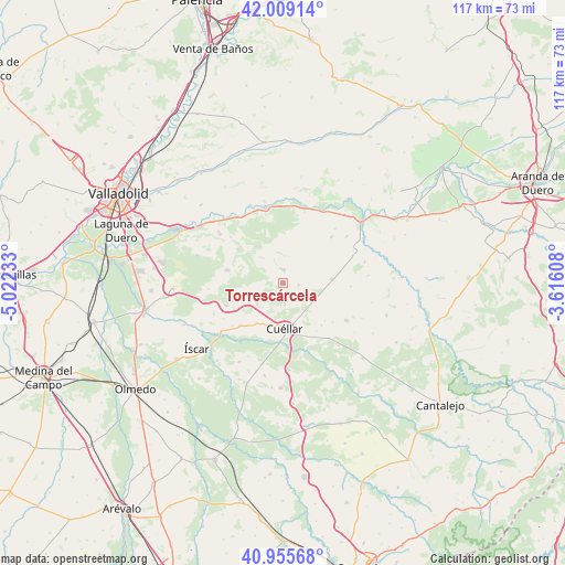
Torrescárcela GPS coordinates[2]
41° 29' 4.38" North, 4° 19' 9.12" West
| Map corner | latitude | longitude |
|---|---|---|
| Upper-left | 42.00914°, | -5.02233° |
| Center: | 41.48455°, | -4.3192° |
| Lower-right: | 40.95568°, | -3.61608° |
| Map W x H: | 117.1×117.1 km | = 72.8×72.8mi |
| max Lat: | 43.74134° ⇑39.5% North |
| Torrescárcela: | 41.48455° |
| min Lat: | ⇓60.5% South 27.64134° |
| min Long | Torrescárcela | max Long |
| -18.00367° | -4.3192° | 4.2899° |
| W 35.9%⇐ | ⇒64.1% E |
Elevation
Elevation of Torrescárcela is 890 m = 2920 ft, and this is 292 m = 958 ft above average elevation for this country.
| Max E: |
1682 m = 5518 ft | 20.8% |
| Torrescárcela | 890 m 2920 ft | |
| Avg. | 598 m = 1962 ft | |
Min E: |
0 m = 0 ft | 79.2% |
See also: Spain elevation on elevation.city.
Geographical zone
Torrescárcela is located in North temperate zone (between Tropic of Cancer and the Arctic Circle). Distance of this Northern Tropic circle is 2006.7 km =1246.9 mi to South.| Distance of | km | miles | from Torrescárcela |
|---|---|---|---|
| North Pole | 5394.4 | 3351.9 | to North |
| Arctic Circle | 2788.5 | 1732.7 | to North |
| Tropic Cancer | 2006.7 | 1246.9 | to South |
| Equator | 4612.6 | 2866.1 | to South |


Nearby cities:
15 places around Torrescárcela: (largest is in red/bold)
• Bahabón
3.3 km =2.1 mi,  96°
96°
• Campaspero
10.3 km =6.4 mi,  85°
85°
• Camporredondo
15.5 km =9.6 mi,  265°
265°
• Cogeces del Monte
2.9 km =1.8 mi,  3°
3°
• Cuéllar
9.2 km =5.7 mi,  177°
177°
• Fompedraza
15.6 km =9.7 mi,  68°
68°
• Langayo
13.8 km =8.6 mi,  46°
46°
• Manzanillo
15.7 km =9.8 mi,  43°
43°
• Montemayor de Pililla
11.8 km =7.3 mi,  283°
283°
• Olombrada
15.3 km =9.5 mi,  120°
120°
• San Cristóbal de Cuéllar
11.3 km =7 mi,  219°
219°
• San Miguel del Arroyo
12.6 km =7.8 mi,  248°
248°
• Santibáñez de Valcorba
14.4 km =8.9 mi,  311°
311°
• Vallelado
12.6 km =7.8 mi,  225°
225°
• Viloria
6.9 km =4.3 mi, 231°
Sources, notices
• [Note1] Compared only with cities in Spain existing in our database
• [Src1] Map data: © OpenStreetMap contributors (CC-BY-SA)
• [Src2] Other city data from geonames.org with taken over terms of usage.
• [Src3] Geographical zone / Annual Mean Temperature by Robert A. Rohde @ Wikipedia
