Sanxenxo geodata
Sanxenxo (Galicia) is a seat of a third-order administrative division; located in Spain in Europe/Madrid (GMT+2) time zone. With population of 17,315 people, there are 543 cities with bigger population in this country. Compared to other cities in Spain, 84.7% of cities are located further ↓South; 97.9% of cities are located further →East and 98.2% of cities have higher elevation than Sanxenxo. Note1


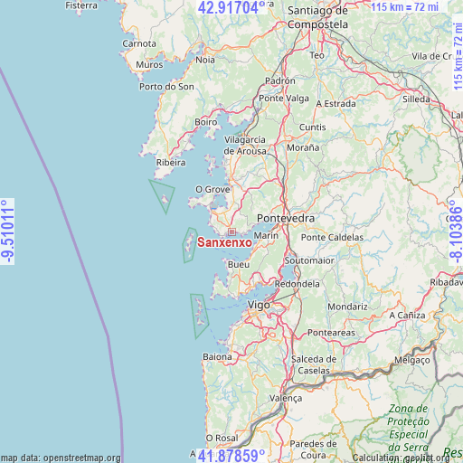
Sanxenxo GPS coordinates[2]
42° 23' 59.856" North, 8° 48' 25.128" West
| Map corner | latitude | longitude |
|---|---|---|
| Upper-left | 42.91704°, | -9.51011° |
| Center: | 42.39996°, | -8.80698° |
| Lower-right: | 41.87859°, | -8.10386° |
| Map W x H: | 115.5×115.5 km | = 71.8×71.8mi |
| max Lat: | 43.74134° ⇑15.3% North |
| Sanxenxo: | 42.39996° |
| min Lat: | ⇓84.7% South 27.64134° |
| min Long | Sanxenxo | max Long |
| -18.00367° | -8.80698° | 4.2899° |
| W 2.1%⇐ | ⇒97.9% E |
Elevation
Elevation of Sanxenxo is 11 m = 36 ft, and this is 587 m = 1926 ft below average elevation for this country.
| Max E: |
1682 m = 5518 ft | 98.2% |
| Avg. | 598 m = 1962 ft | |
| Sanxenxo | 11 m = 36 ft | |
Min E: |
0 m = 0 ft | 1.8% |
See also: Spain elevation on elevation.city.
Geographical zone
Sanxenxo is located in North temperate zone (between Tropic of Cancer and the Arctic Circle). Distance of this Northern Tropic circle is 2108.5 km =1310.2 mi to South.| Distance of | km | miles | from Sanxenxo |
|---|---|---|---|
| North Pole | 5292.6 | 3288.7 | to North |
| Arctic Circle | 2686.7 | 1669.4 | to North |
| Tropic Cancer | 2108.5 | 1310.2 | to South |
| Equator | 4714.4 | 2929.4 | to South |


Nearby cities:
15 places around Sanxenxo: (largest is in red/bold)
• Bueu
8.6 km =5.3 mi,  167°
167°
• Cambados
12.5 km =7.8 mi,  357°
357°
• Cangas do Morrazo
15.2 km =9.4 mi, 173°
• Combarro
9 km =5.6 mi,  66°
66°
• Marín
8.7 km =5.4 mi,  96°
96°
• Meaño
5.6 km =3.5 mi,  22°
22°
• Meis
12.1 km =7.5 mi, 22°
• Moaña
14.7 km =9.1 mi,  157°
157°
• O Grove
11.5 km =7.1 mi,  335°
335°
• Poio
11.3 km =7 mi,  61°
61°
• Poio
12.4 km =7.7 mi, 74°
• Pontevedra
13.8 km =8.6 mi,  75°
75°
• Portonovo
1.7 km =1.1 mi,  247°
247°
• Ribadumia
13.8 km =8.6 mi, 19°
• Vilanova de Arousa
18.3 km =11.4 mi,  354°
354°
Sources, notices
• [Note1] Compared only with cities in Spain existing in our database
• [Src1] Map data: © OpenStreetMap contributors (CC-BY-SA)
• [Src2] Other city data from geonames.org with taken over terms of usage.
• [Src3] Geographical zone / Annual Mean Temperature by Robert A. Rohde @ Wikipedia
