Cambados geodata
Cambados (Galicia) is a seat of a third-order administrative division; located in Spain in Europe/Madrid (GMT+2) time zone. With population of 13,708 people, there are 677 cities with bigger population in this country. Compared to other cities in Spain, 87.4% of cities are located further ↓South; 97.9% of cities are located further →East and 97.3% of cities have higher elevation than Cambados. Note1


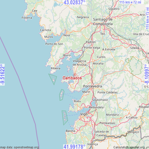
Cambados GPS coordinates[2]
42° 30' 43.992" North, 8° 48' 47.16" West
| Map corner | latitude | longitude |
|---|---|---|
| Upper-left | 43.02837°, | -9.51622° |
| Center: | 42.51222°, | -8.8131° |
| Lower-right: | 41.99178°, | -8.10997° |
| Map W x H: | 115.3×115.3 km | = 71.6×71.6mi |
| max Lat: | 43.74134° ⇑12.6% North |
| Cambados: | 42.51222° |
| min Lat: | ⇓87.4% South 27.64134° |
| min Long | Cambados | max Long |
| -18.00367° | -8.8131° | 4.2899° |
| W 2.1%⇐ | ⇒97.9% E |
Elevation
Elevation of Cambados is 14 m = 46 ft, and this is 584 m = 1916 ft below average elevation for this country.
| Max E: |
1682 m = 5518 ft | 97.3% |
| Avg. | 598 m = 1962 ft | |
| Cambados | 14 m = 46 ft | |
Min E: |
0 m = 0 ft | 2.7% |
See also: Spain elevation on elevation.city.
Geographical zone
Cambados is located in North temperate zone (between Tropic of Cancer and the Arctic Circle). Distance of this Northern Tropic circle is 2121 km =1317.9 mi to South.| Distance of | km | miles | from Cambados |
|---|---|---|---|
| North Pole | 5280.1 | 3280.9 | to North |
| Arctic Circle | 2674.3 | 1661.7 | to North |
| Tropic Cancer | 2121 | 1317.9 | to South |
| Equator | 4726.9 | 2937.2 | to South |


Nearby cities:
15 places around Cambados: (largest is in red/bold)
• A Pobra do Caramiñal
14.4 km =8.9 mi,  314°
314°
• Combarro
12.5 km =7.8 mi,  135°
135°
• Illa de Arousa
7.5 km =4.7 mi,  319°
319°
• Meaño
7.7 km =4.8 mi,  160°
160°
• Meis
5.3 km =3.3 mi,  104°
104°
• O Grove
4.7 km =2.9 mi,  245°
245°
• Palmeira
13.7 km =8.5 mi, 305°
• Poio
12.7 km =7.9 mi,  124°
124°
• Portonovo
13.2 km =8.2 mi,  184°
184°
• Ribadumia
5.2 km =3.2 mi,  84°
84°
• Sanxenxo
12.5 km =7.8 mi, 177°
• Sobradelo
8.3 km =5.2 mi,  17°
17°
• Vilagarcía de Arousa
10.2 km =6.3 mi, 23°
• Vilanova de Arousa
5.9 km =3.7 mi,  348°
348°
• Vilaxoán
8.1 km =5 mi,  11°
11°
Sources, notices
• [Note1] Compared only with cities in Spain existing in our database
• [Src1] Map data: © OpenStreetMap contributors (CC-BY-SA)
• [Src2] Other city data from geonames.org with taken over terms of usage.
• [Src3] Geographical zone / Annual Mean Temperature by Robert A. Rohde @ Wikipedia
