Saldeana geodata
Saldeana (Castille and León) is a seat of a third-order administrative division; located in Spain in Europe/Madrid (GMT+2) time zone. With population of 153 people, there are 5403 cities with bigger population in this country. Compared to other cities in Spain, 51.1% of cities are located further ↑North; 92.3% of cities are located further →East and 50.5% of cities have lower elevation than Saldeana. Note1
Administrative division(s):
- Level 1: Castille and León
- Level 2: Provincia de Salamanca
- Level 3: Saldeana


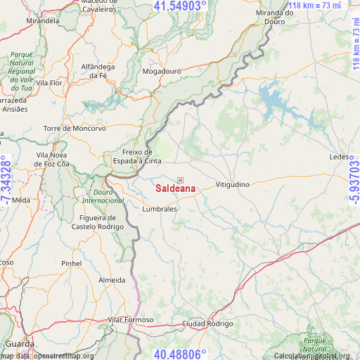
Saldeana GPS coordinates[2]
41° 1' 14.448" North, 6° 38' 24.54" West
| Map corner | latitude | longitude |
|---|---|---|
| Upper-left | 41.54903°, | -7.34328° |
| Center: | 41.02068°, | -6.64015° |
| Lower-right: | 40.48806°, | -5.93703° |
| Map W x H: | 118×118 km | = 73.3×73.3mi |
| max Lat: | 43.74134° ⇑51.1% North |
| Saldeana: | 41.02068° |
| min Lat: | ⇓48.9% South 27.64134° |
| min Long | Saldeana | max Long |
| -18.00367° | -6.64015° | 4.2899° |
| W 7.7%⇐ | ⇒92.3% E |
Elevation
Elevation of Saldeana is 664 m = 2178 ft, and this is 66 m = 217 ft above average elevation for this country.
| Max E: |
1682 m = 5518 ft | 49.5% |
| Saldeana | 664 m 2178 ft | |
| Avg. | 598 m = 1962 ft | |
Min E: |
0 m = 0 ft | 50.5% |
See also: Spain elevation on elevation.city.
Geographical zone
Saldeana is located in North temperate zone (between Tropic of Cancer and the Arctic Circle). Distance of this Northern Tropic circle is 1955.2 km =1214.9 mi to South.| Distance of | km | miles | from Saldeana |
|---|---|---|---|
| North Pole | 5446 | 3384 | to North |
| Arctic Circle | 2840.1 | 1764.8 | to North |
| Tropic Cancer | 1955.2 | 1214.9 | to South |
| Equator | 4561.1 | 2834.1 | to South |


Nearby cities:
15 places around Saldeana: (largest is in red/bold)
• Barruecopardo
6.1 km =3.8 mi,  340°
340°
• Bermellar
3.5 km =2.2 mi,  226°
226°
• Cabeza del Caballo
14 km =8.7 mi,  29°
29°
• Cerezal de Peñahorcada
12.3 km =7.6 mi,  354°
354°
• Cerralbo
6.9 km =4.3 mi,  139°
139°
• Encinasola de los Comendadores
9.1 km =5.7 mi,  82°
82°
• Guadramiro
12.3 km =7.6 mi,  91°
91°
• Hinojosa de Duero
13.6 km =8.5 mi,  253°
253°
• Lumbrales
11.6 km =7.2 mi,  214°
214°
• Saucelle
10 km =6.2 mi,  287°
287°
• Valderrodrigo
12.1 km =7.5 mi,  65°
65°
• Valsalabroso
15.2 km =9.4 mi,  49°
49°
• Villasbuenas
5.9 km =3.7 mi,  38°
38°
• Vilvestre
12 km =7.5 mi,  322°
322°
• Yecla de Yeltes
14.4 km =8.9 mi,  118°
118°
Sources, notices
• [Note1] Compared only with cities in Spain existing in our database
• [Src1] Map data: © OpenStreetMap contributors (CC-BY-SA)
• [Src2] Other city data from geonames.org with taken over terms of usage.
• [Src3] Geographical zone / Annual Mean Temperature by Robert A. Rohde @ Wikipedia
