Saucelle geodata
Saucelle (Castille and León) is a seat of a third-order administrative division; located in Spain in Europe/Madrid (GMT+2) time zone. With population of 384 people, there are 4186 cities with bigger population in this country. Compared to other cities in Spain, 50.4% of cities are located further ↑North; 93.2% of cities are located further →East and 50.7% of cities have lower elevation than Saucelle. Note1
Administrative division(s):
- Level 1: Castille and León
- Level 2: Provincia de Salamanca
- Level 3: Saucelle


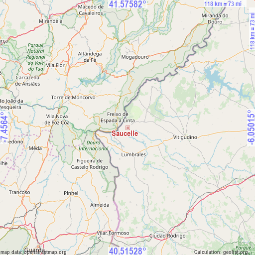
Saucelle GPS coordinates[2]
41° 2' 51.684" North, 6° 45' 11.808" West
| Map corner | latitude | longitude |
|---|---|---|
| Upper-left | 41.57582°, | -7.4564° |
| Center: | 41.04769°, | -6.75328° |
| Lower-right: | 40.51528°, | -6.05015° |
| Map W x H: | 117.9×117.9 km | = 73.3×73.3mi |
| max Lat: | 43.74134° ⇑50.4% North |
| Saucelle: | 41.04769° |
| min Lat: | ⇓49.6% South 27.64134° |
| min Long | Saucelle | max Long |
| -18.00367° | -6.75328° | 4.2899° |
| W 6.8%⇐ | ⇒93.2% E |
Elevation
Elevation of Saucelle is 666 m = 2185 ft, and this is 68 m = 223 ft above average elevation for this country.
| Max E: |
1682 m = 5518 ft | 49.3% |
| Saucelle | 666 m 2185 ft | |
| Avg. | 598 m = 1962 ft | |
Min E: |
0 m = 0 ft | 50.7% |
See also: Spain elevation on elevation.city.
Geographical zone
Saucelle is located in North temperate zone (between Tropic of Cancer and the Arctic Circle). Distance of this Northern Tropic circle is 1958.2 km =1216.8 mi to South.| Distance of | km | miles | from Saucelle |
|---|---|---|---|
| North Pole | 5443 | 3382.1 | to North |
| Arctic Circle | 2837.1 | 1762.9 | to North |
| Tropic Cancer | 1958.2 | 1216.8 | to South |
| Equator | 4564.1 | 2836 | to South |


Nearby cities:
15 places around Saucelle: (largest is in red/bold)
• Ahigal de los Aceiteros
19.5 km =12.1 mi,  178°
178°
• Barruecopardo
7.9 km =4.9 mi,  69°
69°
• Bermellar
8.8 km =5.5 mi,  127°
127°
• Cabeza del Caballo
18.8 km =11.7 mi,  60°
60°
• Cerezal de Peñahorcada
12.5 km =7.8 mi,  42°
42°
• Cerralbo
16.2 km =10.1 mi,  120°
120°
• Encinasola de los Comendadores
18.6 km =11.6 mi,  95°
95°
• Hinojosa de Duero
7.6 km =4.7 mi,  207°
207°
• Lumbrales
12.8 km =8 mi,  167°
167°
• Mieza
14 km =8.7 mi,  21°
21°
• Saldeana
10 km =6.2 mi,  107°
107°
• Sobradillo
14.9 km =9.3 mi,  194°
194°
• Valderrodrigo
20.6 km =12.8 mi,  84°
84°
• Villasbuenas
13.2 km =8.2 mi, 82°
• Vilvestre
6.9 km =4.3 mi, 18°
Sources, notices
• [Note1] Compared only with cities in Spain existing in our database
• [Src1] Map data: © OpenStreetMap contributors (CC-BY-SA)
• [Src2] Other city data from geonames.org with taken over terms of usage.
• [Src3] Geographical zone / Annual Mean Temperature by Robert A. Rohde @ Wikipedia
