Rupià geodata
Rupià (Catalonia) is a seat of a third-order administrative division; located in Spain in Europe/Madrid (GMT+2) time zone. With population of 210 people, there are 4985 cities with bigger population in this country. Compared to other cities in Spain, 74.1% of cities are located further ↓South; 98.8% of cities are located further ←West and 91.2% of cities have higher elevation than Rupià. Note1


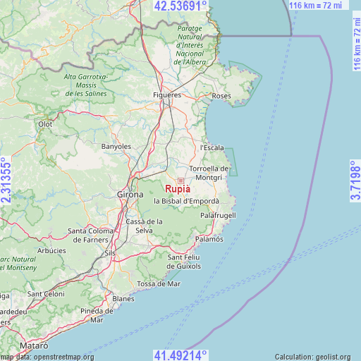
Rupià GPS coordinates[2]
42° 1' 0.012" North, 3° 1' 0.012" East
| Map corner | latitude | longitude |
|---|---|---|
| Upper-left | 42.53691°, | 2.31355° |
| Center: | 42.01667°, | 3.01667° |
| Lower-right: | 41.49214°, | 3.7198° |
| Map W x H: | 116.2×116.2 km | = 72.2×72.2mi |
| max Lat: | 43.74134° ⇑25.9% North |
| Rupià: | 42.01667° |
| min Lat: | ⇓74.1% South 27.64134° |
| min Long | Rupià | max Long |
| -18.00367° | 3.01667° | 4.2899° |
| W 98.8%⇐ | ⇒1.2% E |
Elevation
Elevation of Rupià is 50 m = 164 ft, and this is 548 m = 1798 ft below average elevation for this country.
| Max E: |
1682 m = 5518 ft | 91.2% |
| Avg. | 598 m = 1962 ft | |
| Rupià | 50 m = 164 ft | |
Min E: |
0 m = 0 ft | 8.8% |
See also: Spain elevation on elevation.city.
Geographical zone
Rupià is located in North temperate zone (between Tropic of Cancer and the Arctic Circle). Distance of this Northern Tropic circle is 2065.9 km =1283.7 mi to South.| Distance of | km | miles | from Rupià |
|---|---|---|---|
| North Pole | 5335.2 | 3315.1 | to North |
| Arctic Circle | 2729.4 | 1696 | to North |
| Tropic Cancer | 2065.9 | 1283.7 | to South |
| Equator | 4671.8 | 2902.9 | to South |


Nearby cities:
15 places around Rupià: (largest is in red/bold)
• Corçà
3.7 km =2.3 mi,  180°
180°
• Cruïlles
7.4 km =4.6 mi, 180°
• Flaçà
6.9 km =4.3 mi,  323°
323°
• Foixà
2.6 km =1.6 mi,  328°
328°
• Fontanilles
7.5 km =4.7 mi,  94°
94°
• Gualta
7.3 km =4.5 mi,  78°
78°
• Jafre
6.2 km =3.9 mi,  355°
355°
• Madremanya
5.6 km =3.5 mi,  228°
228°
• Parlavà
1.4 km =0.9 mi,  66°
66°
• Sant Joan de Mollet
6.6 km =4.1 mi,  303°
303°
• Sant Martí Vell
6.9 km =4.3 mi,  270°
270°
• Serra de Daró
4.8 km =3 mi, 73°
• Ullastret
4.5 km =2.8 mi,  114°
114°
• Ultramort
2.6 km =1.6 mi,  33°
33°
• Verges
5.7 km =3.5 mi, 25°
Sources, notices
• [Note1] Compared only with cities in Spain existing in our database
• [Src1] Map data: © OpenStreetMap contributors (CC-BY-SA)
• [Src2] Other city data from geonames.org with taken over terms of usage.
• [Src3] Geographical zone / Annual Mean Temperature by Robert A. Rohde @ Wikipedia
