Parlavà geodata
Parlavà (Catalonia) is a seat of a third-order administrative division; located in Spain in Europe/Madrid (GMT+2) time zone. In our database, there are 6762 cities with bigger population. Compared to other cities in Spain, 74.3% of cities are located further ↓South; 98.9% of cities are located further ←West and 94% of cities have higher elevation than Parlavà. Note1


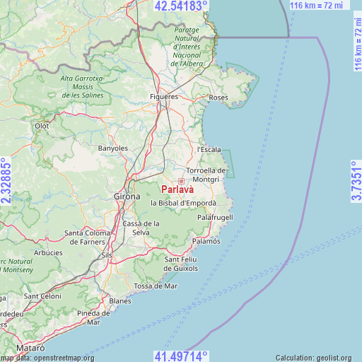
Parlavà GPS coordinates[2]
42° 1' 17.868" North, 3° 1' 55.092" East
| Map corner | latitude | longitude |
|---|---|---|
| Upper-left | 42.54183°, | 2.32885° |
| Center: | 42.02163°, | 3.03197° |
| Lower-right: | 41.49714°, | 3.7351° |
| Map W x H: | 116.2×116.2 km | = 72.2×72.2mi |
| max Lat: | 43.74134° ⇑25.7% North |
| Parlavà: | 42.02163° |
| min Lat: | ⇓74.3% South 27.64134° |
| min Long | Parlavà | max Long |
| -18.00367° | 3.03197° | 4.2899° |
| W 98.9%⇐ | ⇒1.1% E |
Elevation
Elevation of Parlavà is 31 m = 102 ft, and this is 567 m = 1860 ft below average elevation for this country.
| Max E: |
1682 m = 5518 ft | 94% |
| Avg. | 598 m = 1962 ft | |
| Parlavà | 31 m = 102 ft | |
Min E: |
0 m = 0 ft | 6% |
See also: Spain elevation on elevation.city.
Geographical zone
Parlavà is located in North temperate zone (between Tropic of Cancer and the Arctic Circle). Distance of this Northern Tropic circle is 2066.4 km =1284 mi to South.| Distance of | km | miles | from Parlavà |
|---|---|---|---|
| North Pole | 5334.7 | 3314.8 | to North |
| Arctic Circle | 2728.8 | 1695.6 | to North |
| Tropic Cancer | 2066.4 | 1284 | to South |
| Equator | 4672.4 | 2903.3 | to South |


Nearby cities:
15 places around Parlavà: (largest is in red/bold)
• Corçà
4.4 km =2.7 mi,  196°
196°
• Flaçà
7.4 km =4.6 mi,  312°
312°
• Foixà
3.1 km =1.9 mi,  301°
301°
• Fontanilles
6.4 km =4 mi,  100°
100°
• Gualta
5.9 km =3.7 mi,  81°
81°
• Jafre
5.9 km =3.7 mi,  342°
342°
• Madremanya
6.9 km =4.3 mi,  231°
231°
• Palau-sator
7.4 km =4.6 mi,  119°
119°
• Rupià
1.4 km =0.9 mi,  246°
246°
• Serra de Daró
3.4 km =2.1 mi, 76°
• Ullastret
3.7 km =2.3 mi,  129°
129°
• Ullà
7 km =4.3 mi,  63°
63°
• Ultramort
1.7 km =1.1 mi,  7°
7°
• Verges
4.7 km =2.9 mi, 13°
• la Tallada d'Empordà
6.8 km =4.2 mi,  16°
16°
Sources, notices
• [Note1] Compared only with cities in Spain existing in our database
• [Src1] Map data: © OpenStreetMap contributors (CC-BY-SA)
• [Src2] Other city data from geonames.org with taken over terms of usage.
• [Src3] Geographical zone / Annual Mean Temperature by Robert A. Rohde @ Wikipedia
