Fontanilles geodata
Fontanilles (Catalonia) is a seat of a third-order administrative division; located in Spain in Europe/Madrid (GMT+2) time zone. In our database, there are 6762 cities with bigger population. Compared to other cities in Spain, 74% of cities are located further ↓South; 99.4% of cities are located further ←West and 96.6% of cities have higher elevation than Fontanilles. Note1


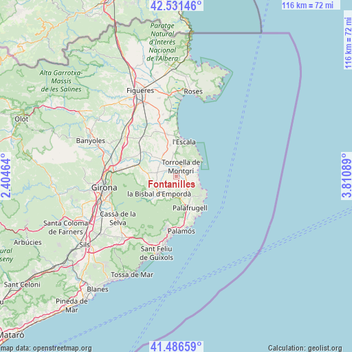
Fontanilles GPS coordinates[2]
42° 0' 40.212" North, 3° 6' 27.936" East
| Map corner | latitude | longitude |
|---|---|---|
| Upper-left | 42.53146°, | 2.40464° |
| Center: | 42.01117°, | 3.10776° |
| Lower-right: | 41.48659°, | 3.81089° |
| Map W x H: | 116.2×116.2 km | = 72.2×72.2mi |
| max Lat: | 43.74134° ⇑26% North |
| Fontanilles: | 42.01117° |
| min Lat: | ⇓74% South 27.64134° |
| min Long | Fontanilles | max Long |
| -18.00367° | 3.10776° | 4.2899° |
| W 99.4%⇐ | ⇒0.59999999999999% E |
Elevation
Elevation of Fontanilles is 17 m = 56 ft, and this is 581 m = 1906 ft below average elevation for this country.
| Max E: |
1682 m = 5518 ft | 96.6% |
| Avg. | 598 m = 1962 ft | |
| Fontanilles | 17 m = 56 ft | |
Min E: |
0 m = 0 ft | 3.4% |
See also: Spain elevation on elevation.city.
Geographical zone
Fontanilles is located in North temperate zone (between Tropic of Cancer and the Arctic Circle). Distance of this Northern Tropic circle is 2065.3 km =1283.3 mi to South.| Distance of | km | miles | from Fontanilles |
|---|---|---|---|
| North Pole | 5335.9 | 3315.6 | to North |
| Arctic Circle | 2730 | 1696.3 | to North |
| Tropic Cancer | 2065.3 | 1283.3 | to South |
| Equator | 4671.2 | 2902.5 | to South |


Nearby cities:
15 places around Fontanilles: (largest is in red/bold)
• Corçà
8.1 km =5 mi,  247°
247°
• Gualta
2.1 km =1.3 mi,  349°
349°
• Palau-sator
2.5 km =1.6 mi,  175°
175°
• Pals
5.6 km =3.5 mi,  143°
143°
• Parlavà
6.4 km =4 mi,  280°
280°
• Regencós
8.3 km =5.2 mi, 141°
• Rupià
7.5 km =4.7 mi,  274°
274°
• Serra de Daró
3.5 km =2.2 mi,  303°
303°
• Torrent
6.7 km =4.2 mi,  166°
166°
• Torroella de Montgrí
3.8 km =2.4 mi,  24°
24°
• Ullastret
3.6 km =2.2 mi, 249°
• Ullà
4.3 km =2.7 mi,  359°
359°
• Ultramort
6.7 km =4.2 mi,  294°
294°
• Verges
7.7 km =4.8 mi,  318°
318°
• la Bisbal d'Empordà
8.3 km =5.2 mi,  215°
215°
Sources, notices
• [Note1] Compared only with cities in Spain existing in our database
• [Src1] Map data: © OpenStreetMap contributors (CC-BY-SA)
• [Src2] Other city data from geonames.org with taken over terms of usage.
• [Src3] Geographical zone / Annual Mean Temperature by Robert A. Rohde @ Wikipedia
